You are here: Home > Network List > G - GEOSCOPE Stations List
> Station CLF Chambon la Foret observatory, France > Earthquake Result Viewer
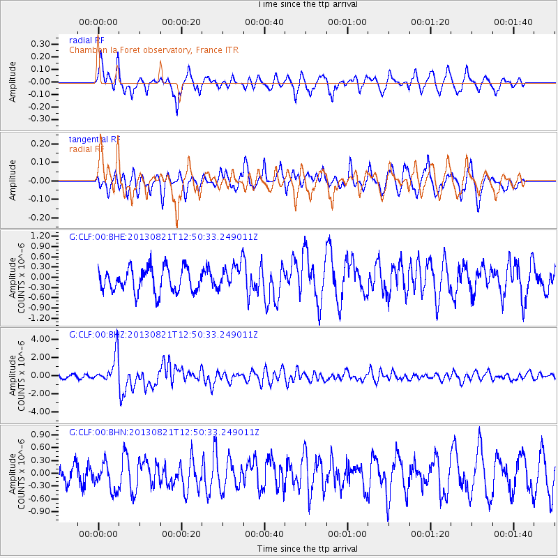
CLF Chambon la Foret observatory, France - Earthquake Result Viewer
*The percent match for this event was below the threshold and hence no stack was calculated.
| Earthquake location: |
Near Coast Of Guerrero, Mexico |
| Earthquake latitude/longitude: |
16.9/-99.5 |
| Earthquake time(UTC): |
2013/08/21 (233) 12:38:29 GMT |
| Earthquake Depth: |
21 km |
| Earthquake Magnitude: |
6.2 MWW, 6.2 MWW, 6.2 MWB, 6.2 MWC |
| Earthquake Catalog/Contributor: |
NEIC PDE/NEIC COMCAT |
|
| Network: |
G GEOSCOPE |
| Station: |
CLF Chambon la Foret observatory, France |
| Lat/Lon: |
48.03 N/2.26 E |
| Elevation: |
145 m |
|
| Distance: |
85.2 deg |
| Az: |
41.259 deg |
| Baz: |
289.846 deg |
| Ray Param: |
$rayparam |
*The percent match for this event was below the threshold and hence was not used in the summary stack. |
|
| Radial Match: |
73.158615 % |
| Radial Bump: |
400 |
| Transverse Match: |
69.87492 % |
| Transverse Bump: |
400 |
| SOD ConfigId: |
626651 |
| Insert Time: |
2014-04-18 01:54:44.820 +0000 |
| GWidth: |
2.5 |
| Max Bumps: |
400 |
| Tol: |
0.001 |
|
Signal To Noise
| Channel | StoN | STA | LTA |
| G:CLF:00:BHZ:20130821T12:50:33.249011Z | 8.927579 | 1.6962136E-6 | 1.8999705E-7 |
| G:CLF:00:BHN:20130821T12:50:33.249011Z | 1.3347785 | 3.600451E-7 | 2.6974146E-7 |
| G:CLF:00:BHE:20130821T12:50:33.249011Z | 1.1385708 | 3.9571836E-7 | 3.4755712E-7 |
| Arrivals |
| Ps | |
| PpPs | |
| PsPs/PpSs | |


