You are here: Home > Network List > LD - Lamont-Doherty Cooperative Seismographic Network Stations List
> Station LUPA Lehigh University, PA > Earthquake Result Viewer
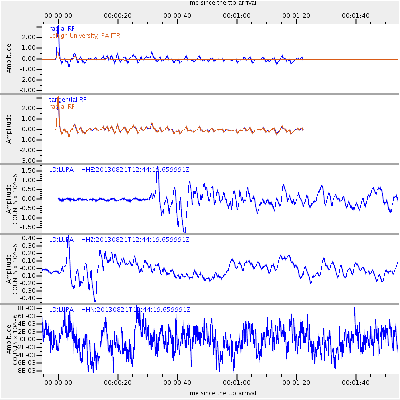
LUPA Lehigh University, PA - Earthquake Result Viewer
*The percent match for this event was below the threshold and hence no stack was calculated.
| Earthquake location: |
Near Coast Of Guerrero, Mexico |
| Earthquake latitude/longitude: |
16.9/-99.5 |
| Earthquake time(UTC): |
2013/08/21 (233) 12:38:29 GMT |
| Earthquake Depth: |
21 km |
| Earthquake Magnitude: |
6.2 MWW, 6.2 MWW, 6.2 MWB, 6.2 MWC |
| Earthquake Catalog/Contributor: |
NEIC PDE/NEIC COMCAT |
|
| Network: |
LD Lamont-Doherty Cooperative Seismographic Network |
| Station: |
LUPA Lehigh University, PA |
| Lat/Lon: |
40.60 N/75.37 W |
| Elevation: |
236 m |
|
| Distance: |
31.5 deg |
| Az: |
36.532 deg |
| Baz: |
228.462 deg |
| Ray Param: |
$rayparam |
*The percent match for this event was below the threshold and hence was not used in the summary stack. |
|
| Radial Match: |
81.28299 % |
| Radial Bump: |
378 |
| Transverse Match: |
81.46253 % |
| Transverse Bump: |
378 |
| SOD ConfigId: |
626651 |
| Insert Time: |
2014-04-18 01:59:46.296 +0000 |
| GWidth: |
2.5 |
| Max Bumps: |
400 |
| Tol: |
0.001 |
|
Signal To Noise
| Channel | StoN | STA | LTA |
| LD:LUPA: :HHZ:20130821T12:44:19.659991Z | 9.544101 | 1.5880373E-7 | 1.6638941E-8 |
| LD:LUPA: :HHN:20130821T12:44:19.659991Z | 0.94906133 | 3.233958E-9 | 3.4075331E-9 |
| LD:LUPA: :HHE:20130821T12:44:19.659991Z | 17.60748 | 6.369997E-7 | 3.6177788E-8 |
| Arrivals |
| Ps | |
| PpPs | |
| PsPs/PpSs | |


