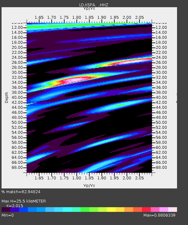
KSPA Keystone College, La Plume, PA - Earthquake Result Viewer

Earthquake location: Near Coast Of Guerrero, Mexico
Earthquake latitude/longitude: 16.9/-99.5
Earthquake time(UTC): 2013/08/21 (233) 12:38:29 GMT
Earthquake Depth: 21 km
Earthquake Magnitude: 6.2 MWW, 6.2 MWW, 6.2 MWB, 6.2 MWC
Earthquake Catalog/Contributor: NEIC PDE/NEIC COMCAT
Network: LD Lamont-Doherty Cooperative Seismographic Network
Station: KSPA Keystone College, La Plume, PA
Lat/Lon: 41.56 N/75.77 W
Elevation: 298 m
Distance: 31.9 deg
Az: 34.803 deg
Baz: 226.732 deg
Ray Param: 0.078837834
Estimated Moho Depth: 25.5 km
Estimated Crust Vp/Vs: 2.02
Assumed Crust Vp: 6.283 km/s
Estimated Crust Vs: 3.118 km/s
Estimated Crust Poisson's Ratio: 0.34
Radial Match: 92.94824 %
Radial Bump: 350
Transverse Match: 82.59286 %
Transverse Bump: 400
SOD ConfigId: 626651
Insert Time: 2014-04-18 01:59:46.903 +0000
GWidth: 2.5
Max Bumps: 400
Tol: 0.001

Signal To Noise

ChannelStoNSTALTA
LD:KSPA: :HHZ:20130821T12:44:23.365009Z19.9488071.8930548E-69.489564E-8
LD:KSPA: :HHN:20130821T12:44:23.365009Z8.18765456.7020113E-78.1855084E-8
LD:KSPA: :HHE:20130821T12:44:23.365009Z11.4504988.6320523E-77.538583E-8
Arrivals
Ps4.4 SECOND
PpPs11 SECOND
PsPs/PpSs16 SECOND