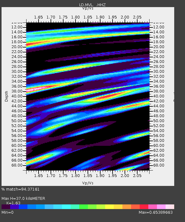
MVL Millersville University, PA - Earthquake Result Viewer

Earthquake location: Near Coast Of Guerrero, Mexico
Earthquake latitude/longitude: 16.9/-99.5
Earthquake time(UTC): 2013/08/21 (233) 12:38:29 GMT
Earthquake Depth: 21 km
Earthquake Magnitude: 6.2 MWW, 6.2 MWW, 6.2 MWB, 6.2 MWC
Earthquake Catalog/Contributor: NEIC PDE/NEIC COMCAT
Network: LD Lamont-Doherty Cooperative Seismographic Network
Station: MVL Millersville University, PA
Lat/Lon: 40.00 N/76.35 W
Elevation: 91 m
Distance: 30.6 deg
Az: 36.426 deg
Baz: 227.74 deg
Ray Param: 0.07928445
Estimated Moho Depth: 37.0 km
Estimated Crust Vp/Vs: 1.63
Assumed Crust Vp: 6.419 km/s
Estimated Crust Vs: 3.938 km/s
Estimated Crust Poisson's Ratio: 0.20
Radial Match: 94.37161 %
Radial Bump: 269
Transverse Match: 83.56696 %
Transverse Bump: 400
SOD ConfigId: 626651
Insert Time: 2014-04-18 01:59:57.043 +0000
GWidth: 2.5
Max Bumps: 400
Tol: 0.001

Signal To Noise

ChannelStoNSTALTA
LD:MVL: :HHZ:20130821T12:44:11.224994Z21.5041181.7213623E-68.004803E-8
LD:MVL: :HHN:20130821T12:44:11.224994Z11.2891437.8961546E-76.9944676E-8
LD:MVL: :HHE:20130821T12:44:11.224994Z14.2037911.0069384E-67.0892234E-8
Arrivals
Ps4.0 SECOND
PpPs14 SECOND
PsPs/PpSs18 SECOND