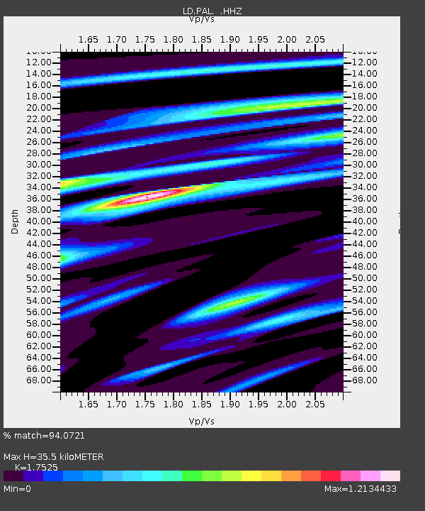
PAL Palisades, New York - Earthquake Result Viewer

Earthquake location: Near Coast Of Guerrero, Mexico
Earthquake latitude/longitude: 16.9/-99.5
Earthquake time(UTC): 2013/08/21 (233) 12:38:29 GMT
Earthquake Depth: 21 km
Earthquake Magnitude: 6.2 MWW, 6.2 MWW, 6.2 MWB, 6.2 MWC
Earthquake Catalog/Contributor: NEIC PDE/NEIC COMCAT
Network: LD Lamont-Doherty Cooperative Seismographic Network
Station: PAL Palisades, New York
Lat/Lon: 41.01 N/73.91 W
Elevation: 66 m
Distance: 32.6 deg
Az: 37.317 deg
Baz: 230.079 deg
Ray Param: 0.0785475
Estimated Moho Depth: 35.5 km
Estimated Crust Vp/Vs: 1.75
Assumed Crust Vp: 6.472 km/s
Estimated Crust Vs: 3.693 km/s
Estimated Crust Poisson's Ratio: 0.26
Radial Match: 94.0721 %
Radial Bump: 326
Transverse Match: 73.85738 %
Transverse Bump: 400
SOD ConfigId: 626651
Insert Time: 2014-04-18 02:00:13.174 +0000
GWidth: 2.5
Max Bumps: 400
Tol: 0.001

Signal To Noise

ChannelStoNSTALTA
LD:PAL: :HHZ:20130821T12:44:29.34801Z24.0703242.0088787E-68.345873E-8
LD:PAL: :HHN:20130821T12:44:29.34801Z12.2936329.553495E-77.771092E-8
LD:PAL: :HHE:20130821T12:44:29.34801Z10.9248711.0184951E-69.32272E-8
Arrivals
Ps4.5 SECOND
PpPs14 SECOND
PsPs/PpSs18 SECOND