You are here: Home > Network List > NE - New England Seismic Network Stations List
> Station TRY Troy, NY, USA > Earthquake Result Viewer
TRY Troy, NY, USA - Earthquake Result Viewer
| Earthquake location: |
Near Coast Of Guerrero, Mexico |
| Earthquake latitude/longitude: |
16.9/-99.5 |
| Earthquake time(UTC): |
2013/08/21 (233) 12:38:29 GMT |
| Earthquake Depth: |
21 km |
| Earthquake Magnitude: |
6.2 MWW, 6.2 MWW, 6.2 MWB, 6.2 MWC |
| Earthquake Catalog/Contributor: |
NEIC PDE/NEIC COMCAT |
|
| Network: |
NE New England Seismic Network |
| Station: |
TRY Troy, NY, USA |
| Lat/Lon: |
42.73 N/73.67 W |
| Elevation: |
89 m |
|
| Distance: |
33.9 deg |
| Az: |
35.149 deg |
| Baz: |
228.428 deg |
| Ray Param: |
0.07797409 |
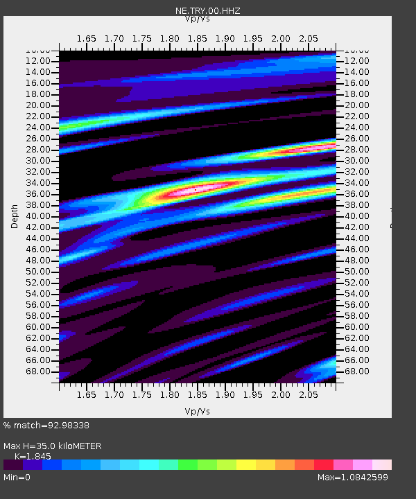
| Estimated Moho Depth: |
35.0 km |
| Estimated Crust Vp/Vs: |
1.85 |
| Assumed Crust Vp: |
6.419 km/s |
| Estimated Crust Vs: |
3.479 km/s |
| Estimated Crust Poisson's Ratio: |
0.29 |
|
| Radial Match: |
92.98338 % |
| Radial Bump: |
284 |
| Transverse Match: |
73.8568 % |
| Transverse Bump: |
400 |
| SOD ConfigId: |
626651 |
| Insert Time: |
2014-04-18 02:01:27.229 +0000 |
| GWidth: |
2.5 |
| Max Bumps: |
400 |
| Tol: |
0.001 |
|

Signal To Noise
| Channel | StoN | STA | LTA |
| NE:TRY:00:HHZ:20130821T12:44:40.325Z | 20.717007 | 1.8119918E-6 | 8.7463974E-8 |
| NE:TRY:00:HH1:20130821T12:44:40.325Z | 5.7586374 | 7.2457965E-7 | 1.2582484E-7 |
| NE:TRY:00:HH2:20130821T12:44:40.325Z | 11.609249 | 1.0977514E-6 | 9.455834E-8 |
| Arrivals |
| Ps | 5.0 SECOND |
| PpPs | 14 SECOND |
| PsPs/PpSs | 19 SECOND |


