You are here: Home > Network List > NI - North-East Italy Broadband Network Stations List
> Station CGRP Cima Grappa > Earthquake Result Viewer
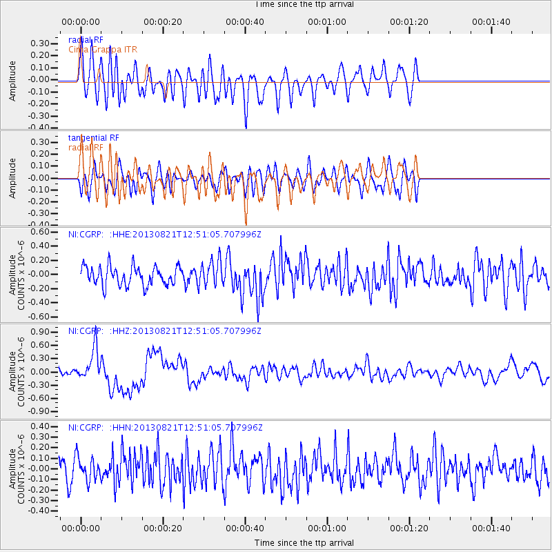
CGRP Cima Grappa - Earthquake Result Viewer
*The percent match for this event was below the threshold and hence no stack was calculated.
| Earthquake location: |
Near Coast Of Guerrero, Mexico |
| Earthquake latitude/longitude: |
16.9/-99.5 |
| Earthquake time(UTC): |
2013/08/21 (233) 12:38:29 GMT |
| Earthquake Depth: |
21 km |
| Earthquake Magnitude: |
6.2 MWW, 6.2 MWW, 6.2 MWB, 6.2 MWC |
| Earthquake Catalog/Contributor: |
NEIC PDE/NEIC COMCAT |
|
| Network: |
NI North-East Italy Broadband Network |
| Station: |
CGRP Cima Grappa |
| Lat/Lon: |
45.88 N/11.80 E |
| Elevation: |
1757 m |
|
| Distance: |
92.1 deg |
| Az: |
40.637 deg |
| Baz: |
296.793 deg |
| Ray Param: |
$rayparam |
*The percent match for this event was below the threshold and hence was not used in the summary stack. |
|
| Radial Match: |
64.73244 % |
| Radial Bump: |
400 |
| Transverse Match: |
54.160645 % |
| Transverse Bump: |
400 |
| SOD ConfigId: |
626651 |
| Insert Time: |
2014-04-18 02:01:47.711 +0000 |
| GWidth: |
2.5 |
| Max Bumps: |
400 |
| Tol: |
0.001 |
|
Signal To Noise
| Channel | StoN | STA | LTA |
| NI:CGRP: :HHZ:20130821T12:51:05.707996Z | 3.9476635 | 3.7134384E-7 | 9.406674E-8 |
| NI:CGRP: :HHN:20130821T12:51:05.707996Z | 1.0420867 | 1.0554832E-7 | 1.01285536E-7 |
| NI:CGRP: :HHE:20130821T12:51:05.707996Z | 1.3250943 | 1.7617747E-7 | 1.3295465E-7 |
| Arrivals |
| Ps | |
| PpPs | |
| PsPs/PpSs | |


