PAGS PA Geological Survey - Earthquake Result Viewer
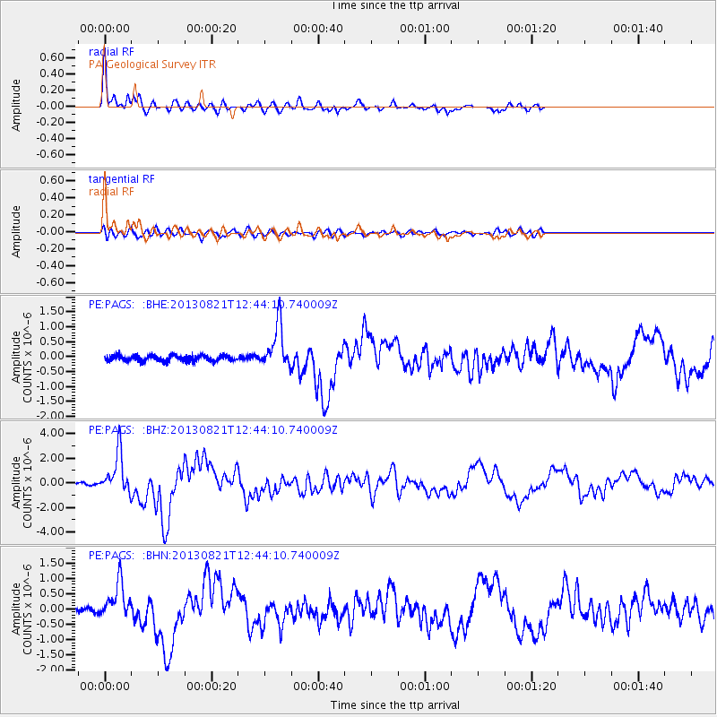
Earthquake location: Near Coast Of Guerrero, Mexico
Earthquake latitude/longitude: 16.9/-99.5
Earthquake time(UTC): 2013/08/21 (233) 12:38:29 GMT
Earthquake Depth: 21 km
Earthquake Magnitude: 6.2 MWW, 6.2 MWW, 6.2 MWB, 6.2 MWC
Earthquake Catalog/Contributor: NEIC PDE/NEIC COMCAT
Network: PE Penn State Network
Station: PAGS PA Geological Survey
Lat/Lon: 40.23 N/76.72 W
Elevation: 120 m
Distance: 30.5 deg
Az: 35.716 deg
Baz: 226.89 deg
Ray Param: 0.07929881
Estimated Moho Depth: 16.5 km
Estimated Crust Vp/Vs: 1.61
Assumed Crust Vp: 6.121 km/s
Estimated Crust Vs: 3.813 km/s
Estimated Crust Poisson's Ratio: 0.18
Radial Match: 93.41483 %
Radial Bump: 398
Transverse Match: 77.43215 %
Transverse Bump: 400
SOD ConfigId: 626651
Insert Time: 2014-04-18 02:02:17.325 +0000
GWidth: 2.5
Max Bumps: 400
Tol: 0.001

Signal To Noise

ChannelStoNSTALTA
PE:PAGS: :BHZ:20130821T12:44:10.740009Z17.3236961.6585011E-69.5735984E-8
PE:PAGS: :BHN:20130821T12:44:10.740009Z6.679586.0905614E-79.1181796E-8
PE:PAGS: :BHE:20130821T12:44:10.740009Z7.45267637.1375973E-79.577228E-8
Arrivals
Ps1.8 SECOND
PpPs6.5 SECOND
PsPs/PpSs8.2 SECOND