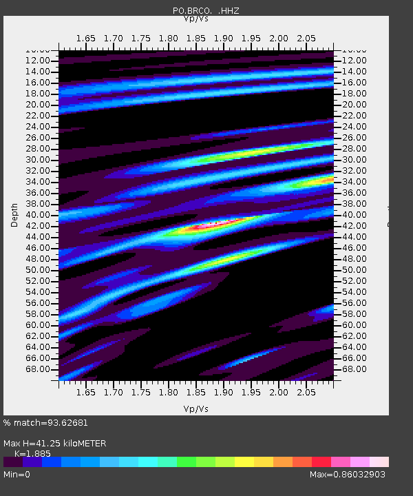
BRCO BRUCE PENN., ON - Earthquake Result Viewer

Earthquake location: Near Coast Of Guerrero, Mexico
Earthquake latitude/longitude: 16.9/-99.5
Earthquake time(UTC): 2013/08/21 (233) 12:38:29 GMT
Earthquake Depth: 21 km
Earthquake Magnitude: 6.2 MWW, 6.2 MWW, 6.2 MWB, 6.2 MWC
Earthquake Catalog/Contributor: NEIC PDE/NEIC COMCAT
Network: PO Portable Observatories for Lithospheric Analysis and Research Investigating Seis
Station: BRCO BRUCE PENN., ON
Lat/Lon: 44.24 N/81.44 W
Elevation: 273 m
Distance: 31.3 deg
Az: 25.428 deg
Baz: 214.89 deg
Ray Param: 0.07910451
Estimated Moho Depth: 41.25 km
Estimated Crust Vp/Vs: 1.88
Assumed Crust Vp: 6.53 km/s
Estimated Crust Vs: 3.464 km/s
Estimated Crust Poisson's Ratio: 0.30
Radial Match: 93.62681 %
Radial Bump: 287
Transverse Match: 88.02576 %
Transverse Bump: 399
SOD ConfigId: 626651
Insert Time: 2014-04-18 02:03:11.728 +0000
GWidth: 2.5
Max Bumps: 400
Tol: 0.001

Signal To Noise

ChannelStoNSTALTA
PO:BRCO: :HHZ:20130821T12:44:17.259998Z9.1615036.5887957E-77.191829E-8
PO:BRCO: :HHN:20130821T12:44:17.259998Z2.6054723.0043543E-71.15309405E-7
PO:BRCO: :HHE:20130821T12:44:17.259998Z4.233914.231478E-79.994256E-8
Arrivals
Ps6.0 SECOND
PpPs17 SECOND
PsPs/PpSs23 SECOND