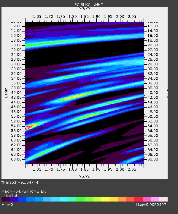
BUKO BUCK LAKE, ON - Earthquake Result Viewer

Earthquake location: Near Coast Of Guerrero, Mexico
Earthquake latitude/longitude: 16.9/-99.5
Earthquake time(UTC): 2013/08/21 (233) 12:38:29 GMT
Earthquake Depth: 21 km
Earthquake Magnitude: 6.2 MWW, 6.2 MWW, 6.2 MWB, 6.2 MWC
Earthquake Catalog/Contributor: NEIC PDE/NEIC COMCAT
Network: PO Portable Observatories for Lithospheric Analysis and Research Investigating Seis
Station: BUKO BUCK LAKE, ON
Lat/Lon: 45.44 N/79.40 W
Elevation: 317 m
Distance: 33.1 deg
Az: 26.315 deg
Baz: 217.077 deg
Ray Param: 0.07835084
Estimated Moho Depth: 54.75 km
Estimated Crust Vp/Vs: 1.60
Assumed Crust Vp: 6.577 km/s
Estimated Crust Vs: 4.111 km/s
Estimated Crust Poisson's Ratio: 0.18
Radial Match: 91.04744 %
Radial Bump: 250
Transverse Match: 58.75926 %
Transverse Bump: 400
SOD ConfigId: 626651
Insert Time: 2014-04-18 02:03:17.514 +0000
GWidth: 2.5
Max Bumps: 400
Tol: 0.001

Signal To Noise

ChannelStoNSTALTA
PO:BUKO: :HHZ:20130821T12:44:33.219989Z12.3739046.687213E-75.404287E-8
PO:BUKO: :HHN:20130821T12:44:33.219989Z8.9894113.2855107E-73.6548673E-8
PO:BUKO: :HHE:20130821T12:44:33.219989Z8.3254722.9949257E-73.5973045E-8
Arrivals
Ps5.5 SECOND
PpPs20 SECOND
PsPs/PpSs25 SECOND