You are here: Home > Network List > PO - Portable Observatories for Lithospheric Analysis and Research Investigating Seis Stations List
> Station ORIO Orleans, Innes Road,, ON > Earthquake Result Viewer
ORIO Orleans, Innes Road,, ON - Earthquake Result Viewer
| Earthquake location: |
Near Coast Of Guerrero, Mexico |
| Earthquake latitude/longitude: |
16.9/-99.5 |
| Earthquake time(UTC): |
2013/08/21 (233) 12:38:29 GMT |
| Earthquake Depth: |
21 km |
| Earthquake Magnitude: |
6.2 MWW, 6.2 MWW, 6.2 MWB, 6.2 MWC |
| Earthquake Catalog/Contributor: |
NEIC PDE/NEIC COMCAT |
|
| Network: |
PO Portable Observatories for Lithospheric Analysis and Research Investigating Seis |
| Station: |
ORIO Orleans, Innes Road,, ON |
| Lat/Lon: |
45.45 N/75.51 W |
| Elevation: |
74 m |
|
| Distance: |
34.8 deg |
| Az: |
30.057 deg |
| Baz: |
222.944 deg |
| Ray Param: |
0.07750589 |
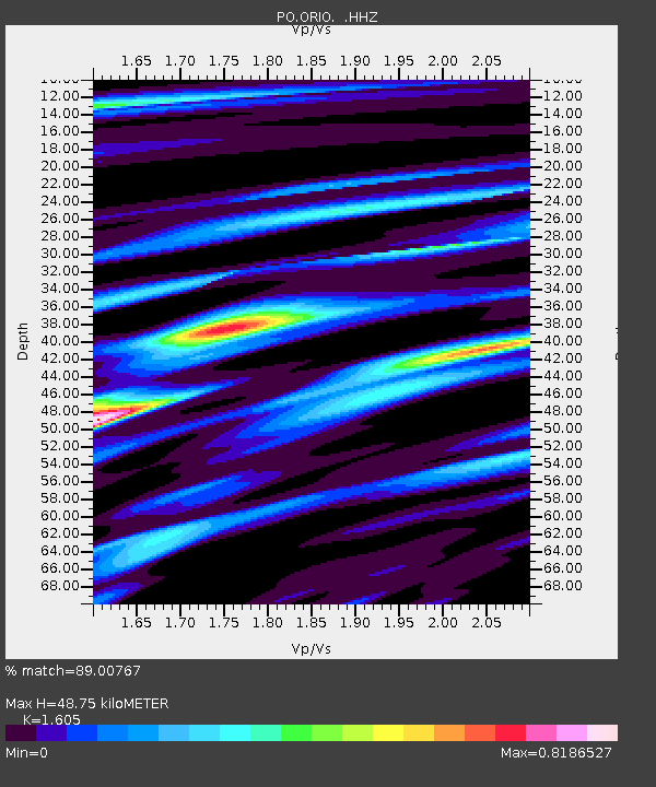
| Estimated Moho Depth: |
48.75 km |
| Estimated Crust Vp/Vs: |
1.61 |
| Assumed Crust Vp: |
6.419 km/s |
| Estimated Crust Vs: |
4.0 km/s |
| Estimated Crust Poisson's Ratio: |
0.18 |
|
| Radial Match: |
89.00767 % |
| Radial Bump: |
300 |
| Transverse Match: |
72.5995 % |
| Transverse Bump: |
400 |
| SOD ConfigId: |
626651 |
| Insert Time: |
2014-04-18 02:03:58.352 +0000 |
| GWidth: |
2.5 |
| Max Bumps: |
400 |
| Tol: |
0.001 |
|

Signal To Noise
| Channel | StoN | STA | LTA |
| PO:ORIO: :HHZ:20130821T12:44:48.520007Z | 19.997387 | 7.13977E-7 | 3.570351E-8 |
| PO:ORIO: :HHN:20130821T12:44:48.520007Z | 5.154965 | 3.0540323E-7 | 5.924448E-8 |
| PO:ORIO: :HHE:20130821T12:44:48.520007Z | 10.222017 | 3.2332704E-7 | 3.1630456E-8 |
| Arrivals |
| Ps | 5.0 SECOND |
| PpPs | 18 SECOND |
| PsPs/PpSs | 23 SECOND |


