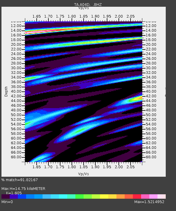
A04D Lummi Island, WA, USA - Earthquake Result Viewer
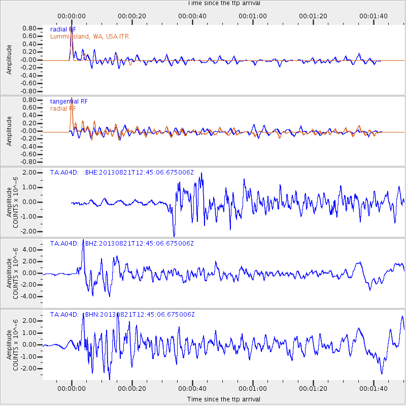
Earthquake location: Near Coast Of Guerrero, Mexico
Earthquake latitude/longitude: 16.9/-99.5
Earthquake time(UTC): 2013/08/21 (233) 12:38:29 GMT
Earthquake Depth: 21 km
Earthquake Magnitude: 6.2 MWW, 6.2 MWW, 6.2 MWB, 6.2 MWC
Earthquake Catalog/Contributor: NEIC PDE/NEIC COMCAT
Network: TA USArray Transportable Network (new EarthScope stations)
Station: A04D Lummi Island, WA, USA
Lat/Lon: 48.72 N/122.71 W
Elevation: 13 m
Distance: 37.0 deg
Az: 334.281 deg
Baz: 141.14 deg
Ray Param: 0.07636489
Estimated Moho Depth: 14.75 km
Estimated Crust Vp/Vs: 1.61
Assumed Crust Vp: 6.566 km/s
Estimated Crust Vs: 4.091 km/s
Estimated Crust Poisson's Ratio: 0.18
Radial Match: 91.82167 %
Radial Bump: 400
Transverse Match: 83.63895 %
Transverse Bump: 400
SOD ConfigId: 626651
Insert Time: 2014-04-18 02:05:42.800 +0000
GWidth: 2.5
Max Bumps: 400
Tol: 0.001

Signal To Noise

ChannelStoNSTALTA
TA:A04D: :BHZ:20130821T12:45:06.675006Z23.7492181.852033E-67.798291E-8
TA:A04D: :BHN:20130821T12:45:06.675006Z6.2191178.7253454E-71.4029878E-7
TA:A04D: :BHE:20130821T12:45:06.675006Z6.83684977.8700054E-71.15111575E-7
Arrivals
Ps1.5 SECOND
PpPs5.4 SECOND
PsPs/PpSs6.8 SECOND