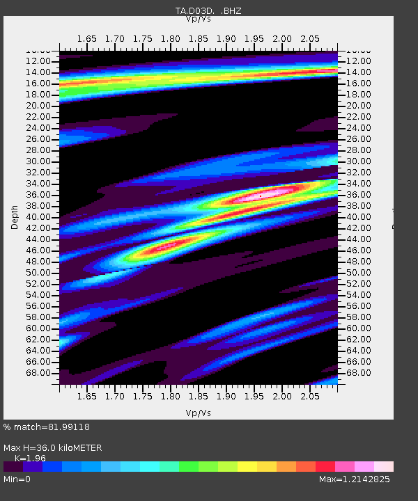
D03D Eldon, WA, USA - Earthquake Result Viewer

Earthquake location: Near Coast Of Guerrero, Mexico
Earthquake latitude/longitude: 16.9/-99.5
Earthquake time(UTC): 2013/08/21 (233) 12:38:29 GMT
Earthquake Depth: 21 km
Earthquake Magnitude: 6.2 MWW, 6.2 MWW, 6.2 MWB, 6.2 MWC
Earthquake Catalog/Contributor: NEIC PDE/NEIC COMCAT
Network: TA USArray Transportable Network (new EarthScope stations)
Station: D03D Eldon, WA, USA
Lat/Lon: 47.53 N/123.09 W
Elevation: 262 m
Distance: 36.2 deg
Az: 332.679 deg
Baz: 139.57 deg
Ray Param: 0.07677312
Estimated Moho Depth: 36.0 km
Estimated Crust Vp/Vs: 1.96
Assumed Crust Vp: 6.566 km/s
Estimated Crust Vs: 3.35 km/s
Estimated Crust Poisson's Ratio: 0.32
Radial Match: 81.99118 %
Radial Bump: 400
Transverse Match: 73.40537 %
Transverse Bump: 400
SOD ConfigId: 626651
Insert Time: 2014-04-18 02:05:51.281 +0000
GWidth: 2.5
Max Bumps: 400
Tol: 0.001

Signal To Noise

ChannelStoNSTALTA
TA:D03D: :BHZ:20130821T12:45:00.300006Z20.6225721.2971905E-66.290149E-8
TA:D03D: :BHN:20130821T12:45:00.300006Z10.271636.4565216E-76.2857815E-8
TA:D03D: :BHE:20130821T12:45:00.300006Z6.5148396.3103914E-79.686181E-8
Arrivals
Ps5.6 SECOND
PpPs15 SECOND
PsPs/PpSs21 SECOND