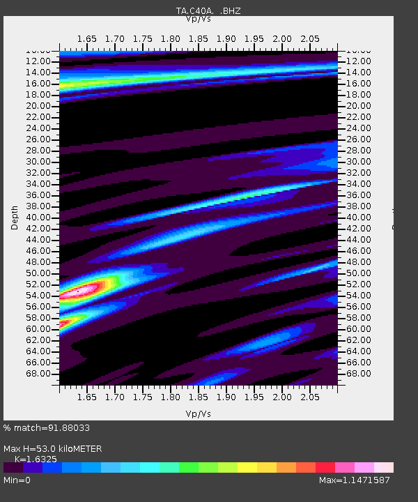
C40A Isle Royale National Park, MI, USA - Earthquake Result Viewer

Earthquake location: Near Coast Of Guerrero, Mexico
Earthquake latitude/longitude: 16.9/-99.5
Earthquake time(UTC): 2013/08/21 (233) 12:38:29 GMT
Earthquake Depth: 21 km
Earthquake Magnitude: 6.2 MWW, 6.2 MWW, 6.2 MWB, 6.2 MWC
Earthquake Catalog/Contributor: NEIC PDE/NEIC COMCAT
Network: TA USArray Transportable Network (new EarthScope stations)
Station: C40A Isle Royale National Park, MI, USA
Lat/Lon: 47.92 N/89.15 W
Elevation: 216 m
Distance: 32.1 deg
Az: 13.142 deg
Baz: 198.881 deg
Ray Param: 0.07877352
Estimated Moho Depth: 53.0 km
Estimated Crust Vp/Vs: 1.63
Assumed Crust Vp: 6.467 km/s
Estimated Crust Vs: 3.961 km/s
Estimated Crust Poisson's Ratio: 0.20
Radial Match: 91.88033 %
Radial Bump: 269
Transverse Match: 67.7481 %
Transverse Bump: 400
SOD ConfigId: 626651
Insert Time: 2014-04-18 02:05:51.634 +0000
GWidth: 2.5
Max Bumps: 400
Tol: 0.001

Signal To Noise

ChannelStoNSTALTA
TA:C40A: :BHZ:20130821T12:44:24.700Z9.3315161.313143E-61.407213E-7
TA:C40A: :BHN:20130821T12:44:24.700Z9.3218928.499288E-79.117558E-8
TA:C40A: :BHE:20130821T12:44:24.700Z4.6176023.3310718E-77.213857E-8
Arrivals
Ps5.7 SECOND
PpPs20 SECOND
PsPs/PpSs25 SECOND