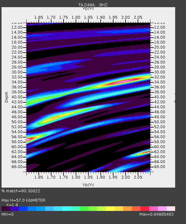
D46A Sault St. Marie, ON, CAN - Earthquake Result Viewer

Earthquake location: Near Coast Of Guerrero, Mexico
Earthquake latitude/longitude: 16.9/-99.5
Earthquake time(UTC): 2013/08/21 (233) 12:38:29 GMT
Earthquake Depth: 21 km
Earthquake Magnitude: 6.2 MWW, 6.2 MWW, 6.2 MWB, 6.2 MWC
Earthquake Catalog/Contributor: NEIC PDE/NEIC COMCAT
Network: TA USArray Transportable Network (new EarthScope stations)
Station: D46A Sault St. Marie, ON, CAN
Lat/Lon: 46.89 N/84.04 W
Elevation: 353 m
Distance: 32.6 deg
Az: 19.865 deg
Baz: 208.32 deg
Ray Param: 0.07858081
Estimated Moho Depth: 57.0 km
Estimated Crust Vp/Vs: 1.60
Assumed Crust Vp: 6.467 km/s
Estimated Crust Vs: 4.042 km/s
Estimated Crust Poisson's Ratio: 0.18
Radial Match: 90.30822 %
Radial Bump: 384
Transverse Match: 72.80431 %
Transverse Bump: 400
SOD ConfigId: 626651
Insert Time: 2014-04-18 02:06:06.126 +0000
GWidth: 2.5
Max Bumps: 400
Tol: 0.001

Signal To Noise

ChannelStoNSTALTA
TA:D46A: :BHZ:20130821T12:44:28.675006Z11.6566551.3872254E-61.1900716E-7
TA:D46A: :BHN:20130821T12:44:28.675006Z9.5762988.0076506E-78.361949E-8
TA:D46A: :BHE:20130821T12:44:28.675006Z4.44026955.009441E-71.12818405E-7
Arrivals
Ps5.8 SECOND
PpPs21 SECOND
PsPs/PpSs27 SECOND