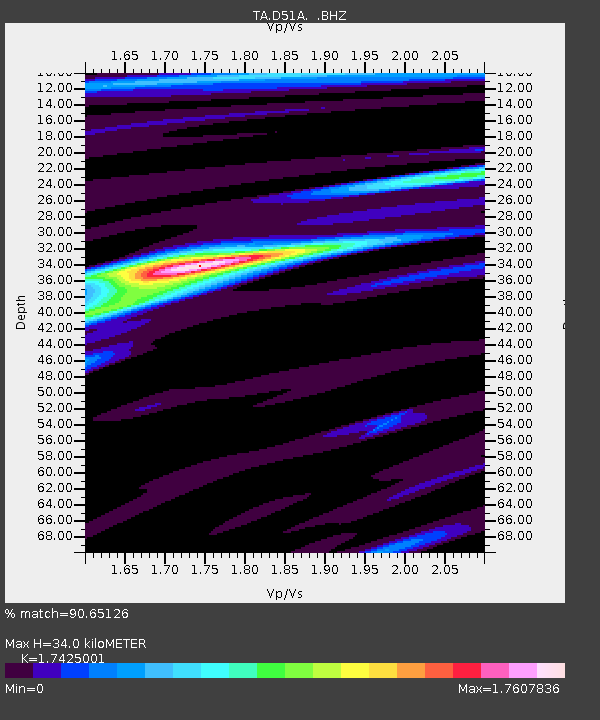
D51A Lot 18 Range III Mazenod Township, QC, CAN - Earthquake Result Viewer
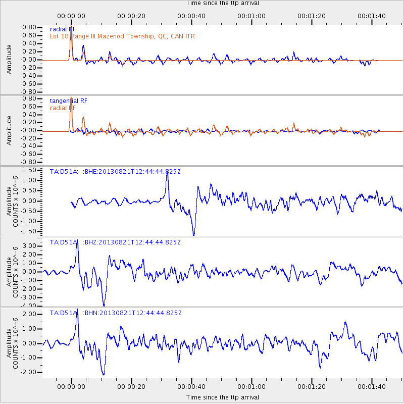
Earthquake location: Near Coast Of Guerrero, Mexico
Earthquake latitude/longitude: 16.9/-99.5
Earthquake time(UTC): 2013/08/21 (233) 12:38:29 GMT
Earthquake Depth: 21 km
Earthquake Magnitude: 6.2 MWW, 6.2 MWW, 6.2 MWB, 6.2 MWC
Earthquake Catalog/Contributor: NEIC PDE/NEIC COMCAT
Network: TA USArray Transportable Network (new EarthScope stations)
Station: D51A Lot 18 Range III Mazenod Township, QC, CAN
Lat/Lon: 47.09 N/79.37 W
Elevation: 282 m
Distance: 34.4 deg
Az: 24.581 deg
Baz: 215.654 deg
Ray Param: 0.0777277
Estimated Moho Depth: 34.0 km
Estimated Crust Vp/Vs: 1.74
Assumed Crust Vp: 6.622 km/s
Estimated Crust Vs: 3.8 km/s
Estimated Crust Poisson's Ratio: 0.25
Radial Match: 90.65126 %
Radial Bump: 385
Transverse Match: 61.35722 %
Transverse Bump: 400
SOD ConfigId: 626651
Insert Time: 2014-04-18 02:06:16.235 +0000
GWidth: 2.5
Max Bumps: 400
Tol: 0.001

Signal To Noise

ChannelStoNSTALTA
TA:D51A: :BHZ:20130821T12:44:44.825Z10.0143471.4991311E-61.4969835E-7
TA:D51A: :BHN:20130821T12:44:44.825Z7.5439799.2859386E-71.2309071E-7
TA:D51A: :BHE:20130821T12:44:44.825Z5.3548145.521079E-71.0310496E-7
Arrivals
Ps4.1 SECOND
PpPs13 SECOND
PsPs/PpSs17 SECOND