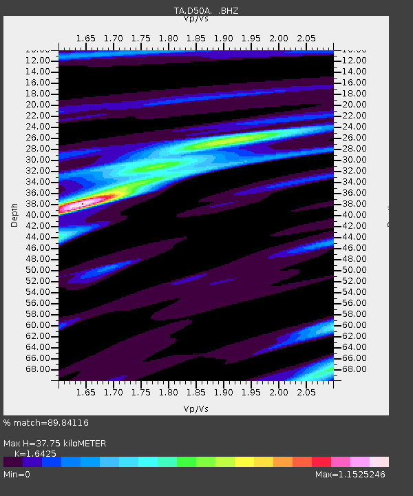
D50A G1974 Best Township, ON, CAN - Earthquake Result Viewer

Earthquake location: Near Coast Of Guerrero, Mexico
Earthquake latitude/longitude: 16.9/-99.5
Earthquake time(UTC): 2013/08/21 (233) 12:38:29 GMT
Earthquake Depth: 21 km
Earthquake Magnitude: 6.2 MWW, 6.2 MWW, 6.2 MWB, 6.2 MWC
Earthquake Catalog/Contributor: NEIC PDE/NEIC COMCAT
Network: TA USArray Transportable Network (new EarthScope stations)
Station: D50A G1974 Best Township, ON, CAN
Lat/Lon: 47.17 N/79.84 W
Elevation: 331 m
Distance: 34.3 deg
Az: 24.04 deg
Baz: 214.866 deg
Ray Param: 0.07779076
Estimated Moho Depth: 37.75 km
Estimated Crust Vp/Vs: 1.64
Assumed Crust Vp: 6.622 km/s
Estimated Crust Vs: 4.032 km/s
Estimated Crust Poisson's Ratio: 0.21
Radial Match: 89.84116 %
Radial Bump: 284
Transverse Match: 63.213478 %
Transverse Bump: 400
SOD ConfigId: 626651
Insert Time: 2014-04-18 02:06:17.680 +0000
GWidth: 2.5
Max Bumps: 400
Tol: 0.001

Signal To Noise

ChannelStoNSTALTA
TA:D50A: :BHZ:20130821T12:44:43.775012Z14.2670151.5542759E-61.08941904E-7
TA:D50A: :BHN:20130821T12:44:43.775012Z12.928329.0055426E-76.965749E-8
TA:D50A: :BHE:20130821T12:44:43.775012Z8.1891196.027544E-77.36043E-8
Arrivals
Ps4.0 SECOND
PpPs14 SECOND
PsPs/PpSs18 SECOND