You are here: Home > Network List > TA - USArray Transportable Network (new EarthScope stations) Stations List
> Station E44A Grand Marais Airport, Grand Marais, MI, USA > Earthquake Result Viewer
E44A Grand Marais Airport, Grand Marais, MI, USA - Earthquake Result Viewer
| Earthquake location: |
Near Coast Of Guerrero, Mexico |
| Earthquake latitude/longitude: |
16.9/-99.5 |
| Earthquake time(UTC): |
2013/08/21 (233) 12:38:29 GMT |
| Earthquake Depth: |
21 km |
| Earthquake Magnitude: |
6.2 MWW, 6.2 MWW, 6.2 MWB, 6.2 MWC |
| Earthquake Catalog/Contributor: |
NEIC PDE/NEIC COMCAT |
|
| Network: |
TA USArray Transportable Network (new EarthScope stations) |
| Station: |
E44A Grand Marais Airport, Grand Marais, MI, USA |
| Lat/Lon: |
46.62 N/85.92 W |
| Elevation: |
282 m |
|
| Distance: |
31.7 deg |
| Az: |
17.92 deg |
| Baz: |
205.303 deg |
| Ray Param: |
0.078932345 |
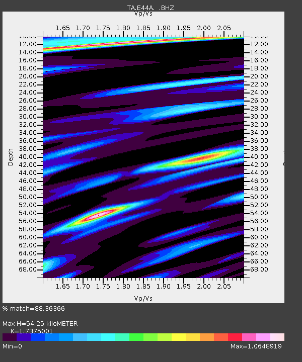
| Estimated Moho Depth: |
54.25 km |
| Estimated Crust Vp/Vs: |
1.74 |
| Assumed Crust Vp: |
6.467 km/s |
| Estimated Crust Vs: |
3.722 km/s |
| Estimated Crust Poisson's Ratio: |
0.25 |
|
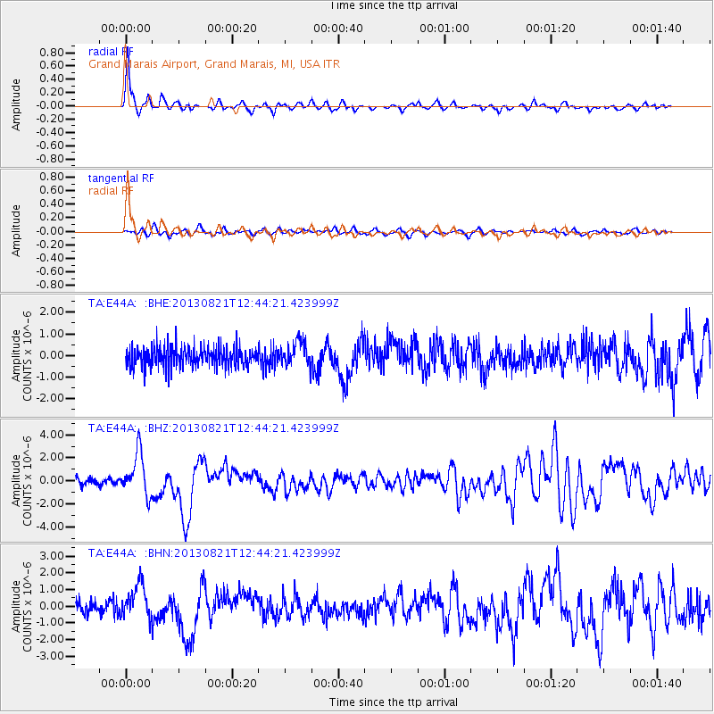
| Radial Match: |
88.36366 % |
| Radial Bump: |
329 |
| Transverse Match: |
64.12449 % |
| Transverse Bump: |
400 |
| SOD ConfigId: |
626651 |
| Insert Time: |
2014-04-18 02:06:55.052 +0000 |
| GWidth: |
2.5 |
| Max Bumps: |
400 |
| Tol: |
0.001 |
|
Signal To Noise
| Channel | StoN | STA | LTA |
| TA:E44A: :BHZ:20130821T12:44:21.423999Z | 7.6419315 | 1.8828395E-6 | 2.4638265E-7 |
| TA:E44A: :BHN:20130821T12:44:21.423999Z | 2.614669 | 1.0564584E-6 | 4.0405052E-7 |
| TA:E44A: :BHE:20130821T12:44:21.423999Z | 1.2941387 | 5.7207757E-7 | 4.4205274E-7 |
| Arrivals |
| Ps | 6.7 SECOND |
| PpPs | 21 SECOND |
| PsPs/PpSs | 28 SECOND |


