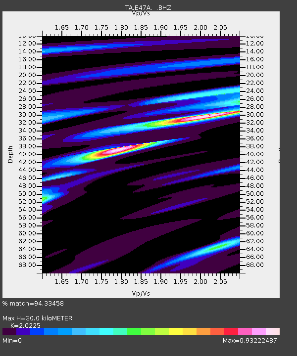
E47A Iron Bridge, ON, CAN - Earthquake Result Viewer

Earthquake location: Near Coast Of Guerrero, Mexico
Earthquake latitude/longitude: 16.9/-99.5
Earthquake time(UTC): 2013/08/21 (233) 12:38:29 GMT
Earthquake Depth: 21 km
Earthquake Magnitude: 6.2 MWW, 6.2 MWW, 6.2 MWB, 6.2 MWC
Earthquake Catalog/Contributor: NEIC PDE/NEIC COMCAT
Network: TA USArray Transportable Network (new EarthScope stations)
Station: E47A Iron Bridge, ON, CAN
Lat/Lon: 46.45 N/83.28 W
Elevation: 246 m
Distance: 32.4 deg
Az: 21.11 deg
Baz: 209.919 deg
Ray Param: 0.078634925
Estimated Moho Depth: 30.0 km
Estimated Crust Vp/Vs: 2.02
Assumed Crust Vp: 6.467 km/s
Estimated Crust Vs: 3.197 km/s
Estimated Crust Poisson's Ratio: 0.34
Radial Match: 94.33458 %
Radial Bump: 223
Transverse Match: 75.05094 %
Transverse Bump: 400
SOD ConfigId: 626651
Insert Time: 2014-04-18 02:07:00.346 +0000
GWidth: 2.5
Max Bumps: 400
Tol: 0.001

Signal To Noise

ChannelStoNSTALTA
TA:E47A: :BHZ:20130821T12:44:27.548999Z10.8190231.7109753E-61.5814508E-7
TA:E47A: :BHN:20130821T12:44:27.548999Z7.625959.762836E-71.2802123E-7
TA:E47A: :BHE:20130821T12:44:27.548999Z5.9281876.431393E-71.0848836E-7
Arrivals
Ps5.1 SECOND
PpPs13 SECOND
PsPs/PpSs18 SECOND