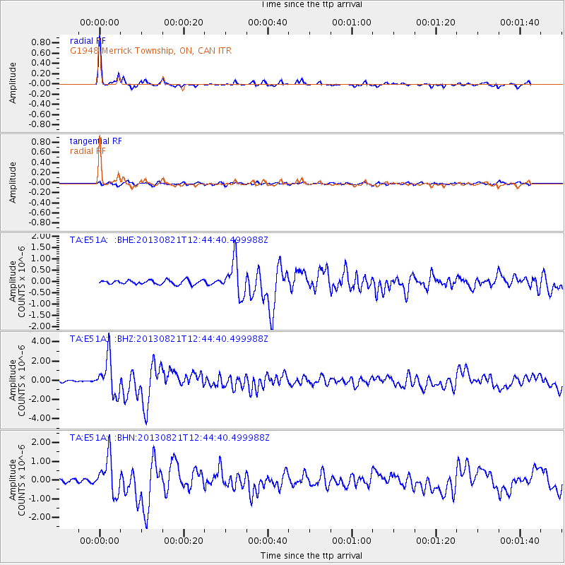
E51A G1948 Merrick Township, ON, CAN - Earthquake Result Viewer
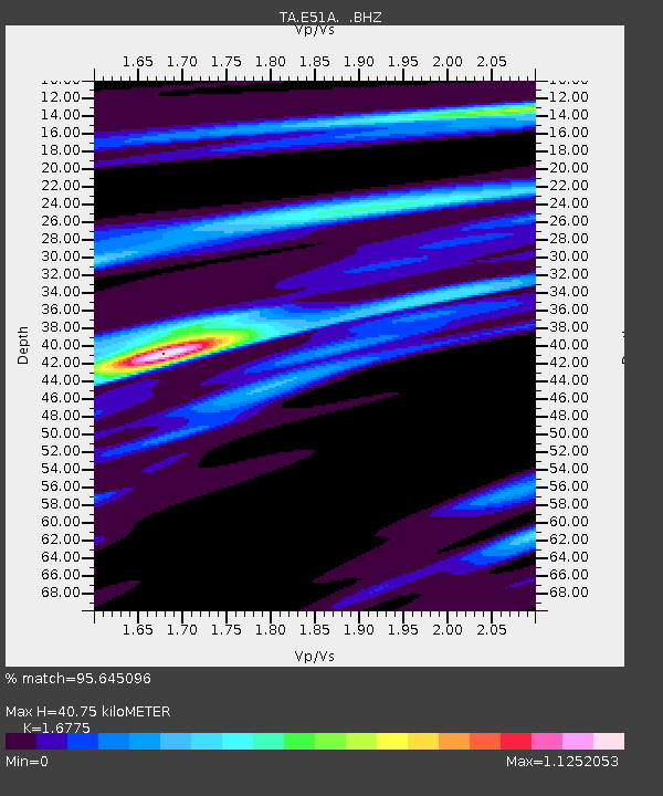
Earthquake location: Near Coast Of Guerrero, Mexico
Earthquake latitude/longitude: 16.9/-99.5
Earthquake time(UTC): 2013/08/21 (233) 12:38:29 GMT
Earthquake Depth: 21 km
Earthquake Magnitude: 6.2 MWW, 6.2 MWW, 6.2 MWB, 6.2 MWC
Earthquake Catalog/Contributor: NEIC PDE/NEIC COMCAT
Network: TA USArray Transportable Network (new EarthScope stations)
Station: E51A G1948 Merrick Township, ON, CAN
Lat/Lon: 46.53 N/79.49 W
Elevation: 369 m
Distance: 33.9 deg
Az: 25.043 deg
Baz: 215.95 deg
Ray Param: 0.07796472
Estimated Moho Depth: 40.75 km
Estimated Crust Vp/Vs: 1.68
Assumed Crust Vp: 6.622 km/s
Estimated Crust Vs: 3.948 km/s
Estimated Crust Poisson's Ratio: 0.22
Radial Match: 95.645096 %
Radial Bump: 190
Transverse Match: 78.71218 %
Transverse Bump: 400
SOD ConfigId: 626651
Insert Time: 2014-04-18 02:07:09.029 +0000
GWidth: 2.5
Max Bumps: 400
Tol: 0.001

Signal To Noise

ChannelStoNSTALTA
TA:E51A: :BHZ:20130821T12:44:40.499988Z21.1463361.9321776E-69.137175E-8
TA:E51A: :BHN:20130821T12:44:40.499988Z13.2985951.0000634E-67.520068E-8
TA:E51A: :BHE:20130821T12:44:40.499988Z8.6268217.775042E-79.012639E-8
Arrivals
Ps4.6 SECOND
PpPs15 SECOND
PsPs/PpSs20 SECOND