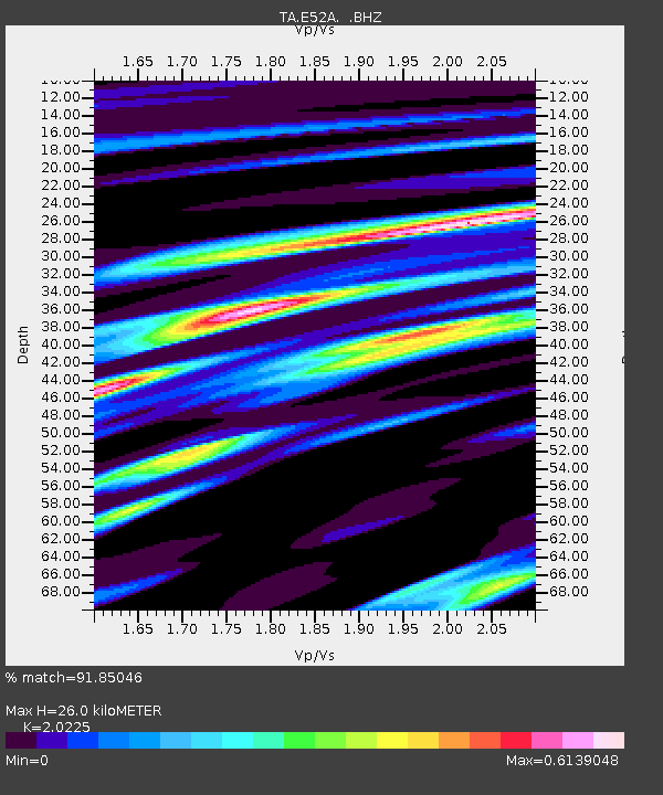
E52A Mattawa, ON, CAN - Earthquake Result Viewer
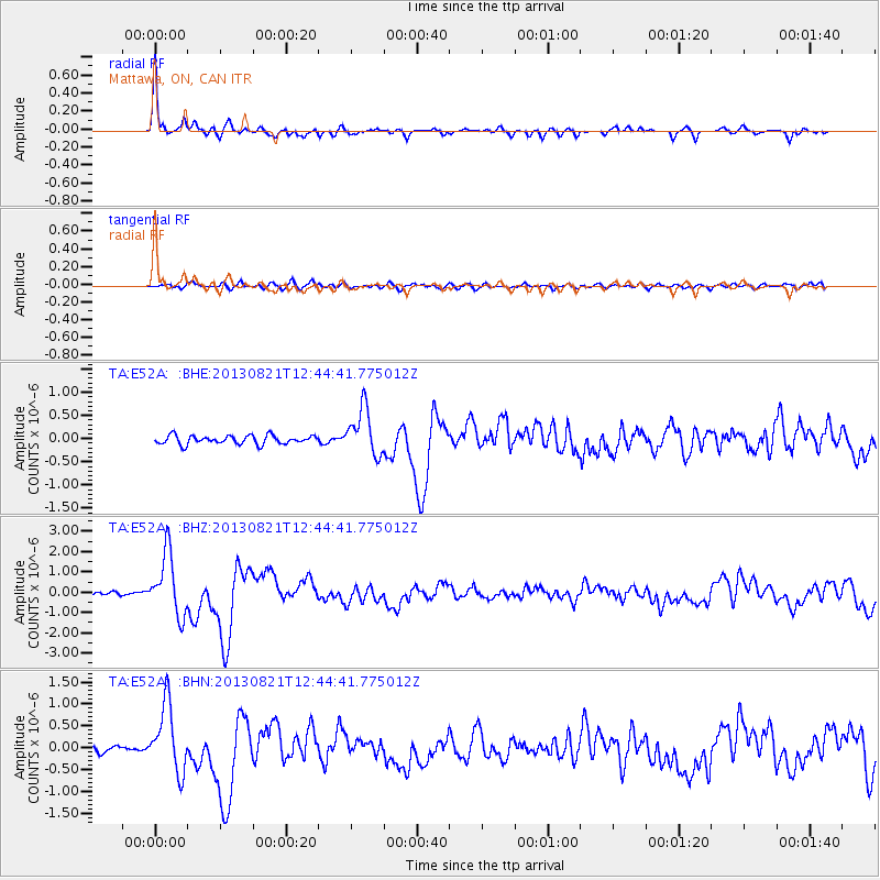
Earthquake location: Near Coast Of Guerrero, Mexico
Earthquake latitude/longitude: 16.9/-99.5
Earthquake time(UTC): 2013/08/21 (233) 12:38:29 GMT
Earthquake Depth: 21 km
Earthquake Magnitude: 6.2 MWW, 6.2 MWW, 6.2 MWB, 6.2 MWC
Earthquake Catalog/Contributor: NEIC PDE/NEIC COMCAT
Network: TA USArray Transportable Network (new EarthScope stations)
Station: E52A Mattawa, ON, CAN
Lat/Lon: 46.29 N/78.66 W
Elevation: 252 m
Distance: 34.1 deg
Az: 26.138 deg
Baz: 217.461 deg
Ray Param: 0.077897295
Estimated Moho Depth: 26.0 km
Estimated Crust Vp/Vs: 2.02
Assumed Crust Vp: 6.622 km/s
Estimated Crust Vs: 3.274 km/s
Estimated Crust Poisson's Ratio: 0.34
Radial Match: 91.85046 %
Radial Bump: 275
Transverse Match: 62.569023 %
Transverse Bump: 400
SOD ConfigId: 626651
Insert Time: 2014-04-18 02:07:09.935 +0000
GWidth: 2.5
Max Bumps: 400
Tol: 0.001

Signal To Noise

ChannelStoNSTALTA
TA:E52A: :BHZ:20130821T12:44:41.775012Z12.7817171.5158728E-61.1859696E-7
TA:E52A: :BHN:20130821T12:44:41.775012Z5.5058737.730957E-71.4041291E-7
TA:E52A: :BHE:20130821T12:44:41.775012Z5.33155545.0039364E-79.38551E-8
Arrivals
Ps4.3 SECOND
PpPs11 SECOND
PsPs/PpSs15 SECOND