You are here: Home > Network List > TA - USArray Transportable Network (new EarthScope stations) Stations List
> Station E53A Dumoine, Pontiac MRC, QC, CAN > Earthquake Result Viewer
E53A Dumoine, Pontiac MRC, QC, CAN - Earthquake Result Viewer
| Earthquake location: |
Near Coast Of Guerrero, Mexico |
| Earthquake latitude/longitude: |
16.9/-99.5 |
| Earthquake time(UTC): |
2013/08/21 (233) 12:38:29 GMT |
| Earthquake Depth: |
21 km |
| Earthquake Magnitude: |
6.2 MWW, 6.2 MWW, 6.2 MWB, 6.2 MWC |
| Earthquake Catalog/Contributor: |
NEIC PDE/NEIC COMCAT |
|
| Network: |
TA USArray Transportable Network (new EarthScope stations) |
| Station: |
E53A Dumoine, Pontiac MRC, QC, CAN |
| Lat/Lon: |
46.38 N/77.66 W |
| Elevation: |
355 m |
|
| Distance: |
34.6 deg |
| Az: |
26.995 deg |
| Baz: |
218.885 deg |
| Ray Param: |
0.07765262 |
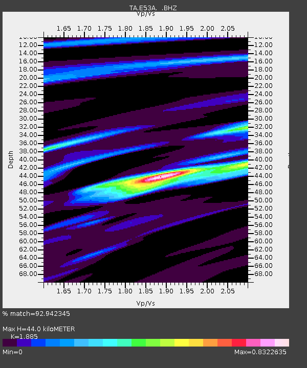
| Estimated Moho Depth: |
44.0 km |
| Estimated Crust Vp/Vs: |
1.88 |
| Assumed Crust Vp: |
6.622 km/s |
| Estimated Crust Vs: |
3.513 km/s |
| Estimated Crust Poisson's Ratio: |
0.30 |
|
| Radial Match: |
92.942345 % |
| Radial Bump: |
291 |
| Transverse Match: |
75.055115 % |
| Transverse Bump: |
400 |
| SOD ConfigId: |
626651 |
| Insert Time: |
2014-04-18 02:07:13.527 +0000 |
| GWidth: |
2.5 |
| Max Bumps: |
400 |
| Tol: |
0.001 |
|

Signal To Noise
| Channel | StoN | STA | LTA |
| TA:E53A: :BHZ:20130821T12:44:46.075Z | 12.378961 | 1.6215827E-6 | 1.3099506E-7 |
| TA:E53A: :BHN:20130821T12:44:46.075Z | 7.440778 | 9.630212E-7 | 1.2942479E-7 |
| TA:E53A: :BHE:20130821T12:44:46.075Z | 9.610164 | 7.583181E-7 | 7.890793E-8 |
| Arrivals |
| Ps | 6.4 SECOND |
| PpPs | 18 SECOND |
| PsPs/PpSs | 24 SECOND |


