You are here: Home > Network List > TA - USArray Transportable Network (new EarthScope stations) Stations List
> Station E57A Chemin Saint Guillaume, Saint Donat, QC, CAN > Earthquake Result Viewer
E57A Chemin Saint Guillaume, Saint Donat, QC, CAN - Earthquake Result Viewer
| Earthquake location: |
Near Coast Of Guerrero, Mexico |
| Earthquake latitude/longitude: |
16.9/-99.5 |
| Earthquake time(UTC): |
2013/08/21 (233) 12:38:29 GMT |
| Earthquake Depth: |
21 km |
| Earthquake Magnitude: |
6.2 MWW, 6.2 MWW, 6.2 MWB, 6.2 MWC |
| Earthquake Catalog/Contributor: |
NEIC PDE/NEIC COMCAT |
|
| Network: |
TA USArray Transportable Network (new EarthScope stations) |
| Station: |
E57A Chemin Saint Guillaume, Saint Donat, QC, CAN |
| Lat/Lon: |
46.41 N/74.15 W |
| Elevation: |
572 m |
|
| Distance: |
36.2 deg |
| Az: |
30.109 deg |
| Baz: |
223.963 deg |
| Ray Param: |
0.076785624 |
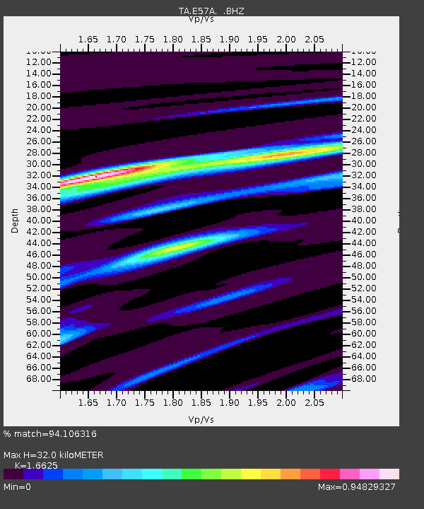
| Estimated Moho Depth: |
32.0 km |
| Estimated Crust Vp/Vs: |
1.66 |
| Assumed Crust Vp: |
6.61 km/s |
| Estimated Crust Vs: |
3.976 km/s |
| Estimated Crust Poisson's Ratio: |
0.22 |
|
| Radial Match: |
94.106316 % |
| Radial Bump: |
220 |
| Transverse Match: |
76.49487 % |
| Transverse Bump: |
400 |
| SOD ConfigId: |
626651 |
| Insert Time: |
2014-04-18 02:07:22.944 +0000 |
| GWidth: |
2.5 |
| Max Bumps: |
400 |
| Tol: |
0.001 |
|
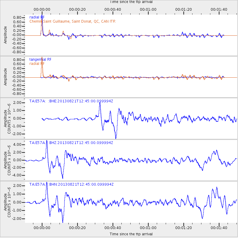
Signal To Noise
| Channel | StoN | STA | LTA |
| TA:E57A: :BHZ:20130821T12:45:00.099994Z | 18.457636 | 2.101104E-6 | 1.13833856E-7 |
| TA:E57A: :BHN:20130821T12:45:00.099994Z | 15.686221 | 1.0200143E-6 | 6.502614E-8 |
| TA:E57A: :BHE:20130821T12:45:00.099994Z | 10.979511 | 9.060237E-7 | 8.251949E-8 |
| Arrivals |
| Ps | 3.5 SECOND |
| PpPs | 12 SECOND |
| PsPs/PpSs | 15 SECOND |


