F49A Sandfield, ON, CAN - Earthquake Result Viewer
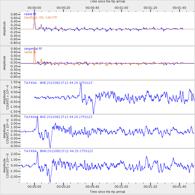
Earthquake location: Near Coast Of Guerrero, Mexico
Earthquake latitude/longitude: 16.9/-99.5
Earthquake time(UTC): 2013/08/21 (233) 12:38:29 GMT
Earthquake Depth: 21 km
Earthquake Magnitude: 6.2 MWW, 6.2 MWW, 6.2 MWB, 6.2 MWC
Earthquake Catalog/Contributor: NEIC PDE/NEIC COMCAT
Network: TA USArray Transportable Network (new EarthScope stations)
Station: F49A Sandfield, ON, CAN
Lat/Lon: 45.76 N/82.04 W
Elevation: 230 m
Distance: 32.3 deg
Az: 23.154 deg
Baz: 212.534 deg
Ray Param: 0.07869712
Estimated Moho Depth: 19.0 km
Estimated Crust Vp/Vs: 2.10
Assumed Crust Vp: 6.483 km/s
Estimated Crust Vs: 3.091 km/s
Estimated Crust Poisson's Ratio: 0.35
Radial Match: 94.00843 %
Radial Bump: 324
Transverse Match: 66.8786 %
Transverse Bump: 400
SOD ConfigId: 626651
Insert Time: 2014-04-18 02:07:54.147 +0000
GWidth: 2.5
Max Bumps: 400
Tol: 0.001

Signal To Noise

ChannelStoNSTALTA
TA:F49A: :BHZ:20130821T12:44:26.275012Z13.7281131.6054587E-61.1694679E-7
TA:F49A: :BHN:20130821T12:44:26.275012Z9.1084239.2666187E-71.017368E-7
TA:F49A: :BHE:20130821T12:44:26.275012Z6.9469335.578452E-78.030094E-8
Arrivals
Ps3.4 SECOND
PpPs8.5 SECOND
PsPs/PpSs12 SECOND