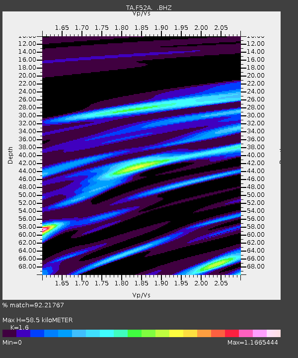
F52A Sundridge, ON, CAN - Earthquake Result Viewer
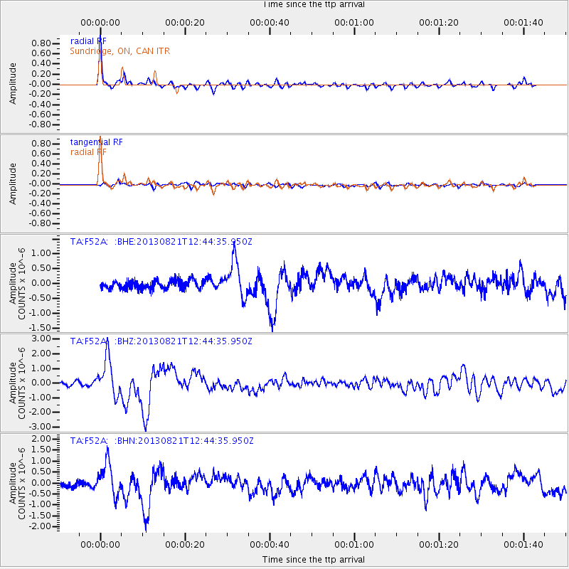
Earthquake location: Near Coast Of Guerrero, Mexico
Earthquake latitude/longitude: 16.9/-99.5
Earthquake time(UTC): 2013/08/21 (233) 12:38:29 GMT
Earthquake Depth: 21 km
Earthquake Magnitude: 6.2 MWW, 6.2 MWW, 6.2 MWB, 6.2 MWC
Earthquake Catalog/Contributor: NEIC PDE/NEIC COMCAT
Network: TA USArray Transportable Network (new EarthScope stations)
Station: F52A Sundridge, ON, CAN
Lat/Lon: 45.80 N/79.32 W
Elevation: 351 m
Distance: 33.4 deg
Az: 26.005 deg
Baz: 216.873 deg
Ray Param: 0.07820602
Estimated Moho Depth: 58.5 km
Estimated Crust Vp/Vs: 1.60
Assumed Crust Vp: 6.577 km/s
Estimated Crust Vs: 4.111 km/s
Estimated Crust Poisson's Ratio: 0.18
Radial Match: 92.21767 %
Radial Bump: 395
Transverse Match: 70.68015 %
Transverse Bump: 400
SOD ConfigId: 626651
Insert Time: 2014-04-18 02:07:59.824 +0000
GWidth: 2.5
Max Bumps: 400
Tol: 0.001

Signal To Noise

ChannelStoNSTALTA
TA:F52A: :BHZ:20130821T12:44:35.950Z11.7338661.3025303E-61.11006074E-7
TA:F52A: :BHN:20130821T12:44:35.950Z6.9757687.5742355E-71.0857923E-7
TA:F52A: :BHE:20130821T12:44:35.950Z4.17504456.2246085E-71.4909082E-7
Arrivals
Ps5.8 SECOND
PpPs21 SECOND
PsPs/PpSs27 SECOND