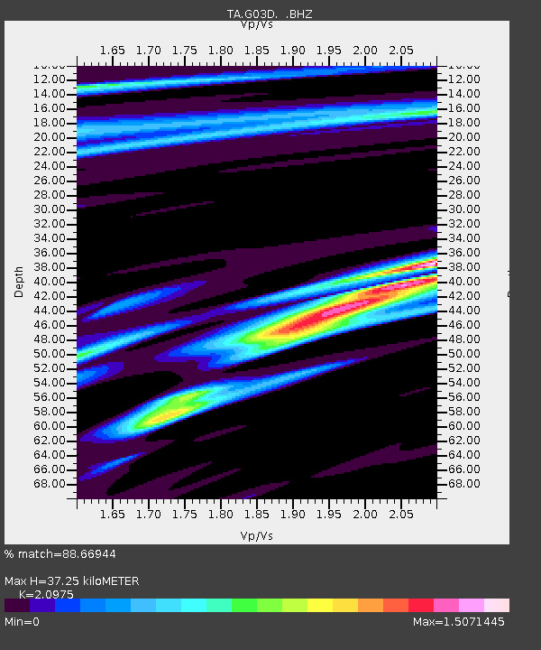
G03D McMinnville, OR, USA - Earthquake Result Viewer

Earthquake location: Near Coast Of Guerrero, Mexico
Earthquake latitude/longitude: 16.9/-99.5
Earthquake time(UTC): 2013/08/21 (233) 12:38:29 GMT
Earthquake Depth: 21 km
Earthquake Magnitude: 6.2 MWW, 6.2 MWW, 6.2 MWB, 6.2 MWC
Earthquake Catalog/Contributor: NEIC PDE/NEIC COMCAT
Network: TA USArray Transportable Network (new EarthScope stations)
Station: G03D McMinnville, OR, USA
Lat/Lon: 45.21 N/123.26 W
Elevation: 222 m
Distance: 34.6 deg
Az: 329.857 deg
Baz: 137.142 deg
Ray Param: 0.077651575
Estimated Moho Depth: 37.25 km
Estimated Crust Vp/Vs: 2.10
Assumed Crust Vp: 6.566 km/s
Estimated Crust Vs: 3.13 km/s
Estimated Crust Poisson's Ratio: 0.35
Radial Match: 88.66944 %
Radial Bump: 400
Transverse Match: 60.667065 %
Transverse Bump: 400
SOD ConfigId: 626651
Insert Time: 2014-04-18 02:08:20.602 +0000
GWidth: 2.5
Max Bumps: 400
Tol: 0.001

Signal To Noise

ChannelStoNSTALTA
TA:G03D: :BHZ:20130821T12:44:46.099994Z5.5207652.0060947E-63.633726E-7
TA:G03D: :BHN:20130821T12:44:46.099994Z2.36934839.037109E-73.814175E-7
TA:G03D: :BHE:20130821T12:44:46.099994Z2.184397.9380834E-73.6340046E-7
Arrivals
Ps6.7 SECOND
PpPs16 SECOND
PsPs/PpSs23 SECOND