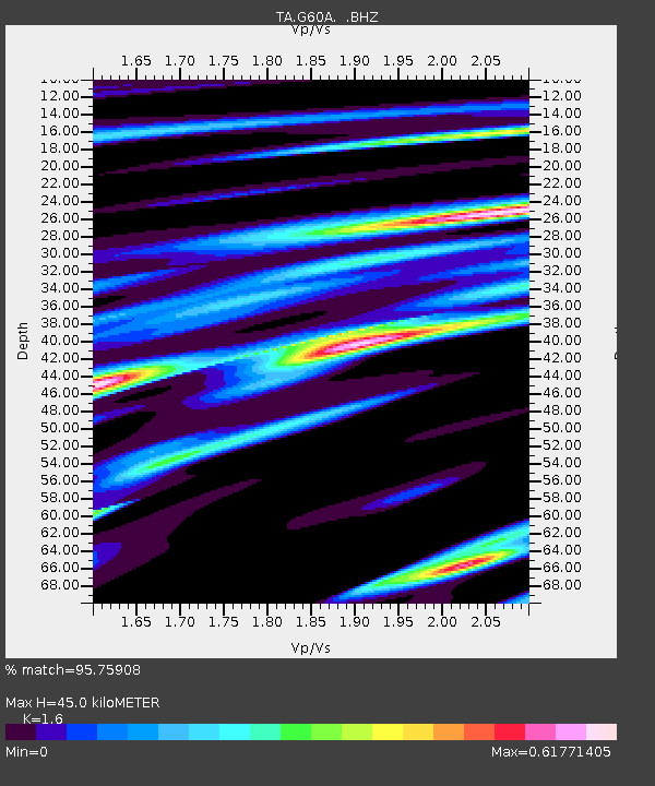
G60A Masonville, QC, CAN - Earthquake Result Viewer

Earthquake location: Near Coast Of Guerrero, Mexico
Earthquake latitude/longitude: 16.9/-99.5
Earthquake time(UTC): 2013/08/21 (233) 12:38:29 GMT
Earthquake Depth: 21 km
Earthquake Magnitude: 6.2 MWW, 6.2 MWW, 6.2 MWB, 6.2 MWC
Earthquake Catalog/Contributor: NEIC PDE/NEIC COMCAT
Network: TA USArray Transportable Network (new EarthScope stations)
Station: G60A Masonville, QC, CAN
Lat/Lon: 45.10 N/72.33 W
Elevation: 391 m
Distance: 36.2 deg
Az: 33.204 deg
Baz: 227.756 deg
Ray Param: 0.076787814
Estimated Moho Depth: 45.0 km
Estimated Crust Vp/Vs: 1.60
Assumed Crust Vp: 6.419 km/s
Estimated Crust Vs: 4.012 km/s
Estimated Crust Poisson's Ratio: 0.18
Radial Match: 95.75908 %
Radial Bump: 259
Transverse Match: 88.86474 %
Transverse Bump: 400
SOD ConfigId: 626651
Insert Time: 2014-04-18 02:09:00.206 +0000
GWidth: 2.5
Max Bumps: 400
Tol: 0.001

Signal To Noise

ChannelStoNSTALTA
TA:G60A: :BHZ:20130821T12:45:00.075Z19.977592.2291154E-61.1158079E-7
TA:G60A: :BHN:20130821T12:45:00.075Z9.5055199.92048E-71.0436547E-7
TA:G60A: :BHE:20130821T12:45:00.075Z10.8110851.0506569E-69.71833E-8
Arrivals
Ps4.6 SECOND
PpPs17 SECOND
PsPs/PpSs21 SECOND