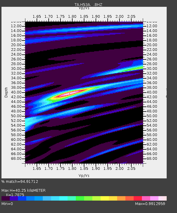
H53A Bobcaygeon, ON, CAN - Earthquake Result Viewer
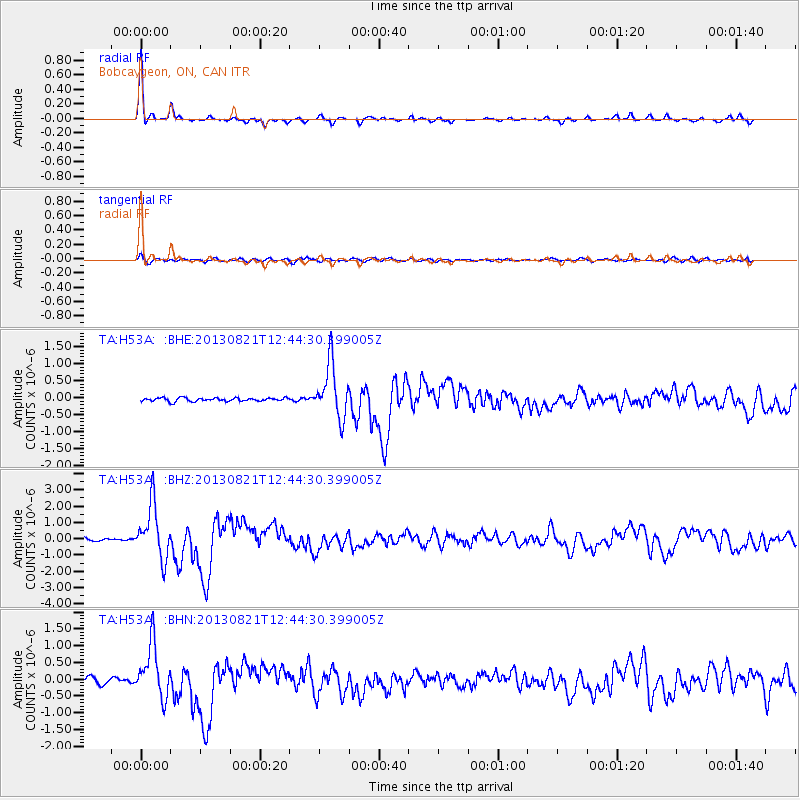
Earthquake location: Near Coast Of Guerrero, Mexico
Earthquake latitude/longitude: 16.9/-99.5
Earthquake time(UTC): 2013/08/21 (233) 12:38:29 GMT
Earthquake Depth: 21 km
Earthquake Magnitude: 6.2 MWW, 6.2 MWW, 6.2 MWB, 6.2 MWC
Earthquake Catalog/Contributor: NEIC PDE/NEIC COMCAT
Network: TA USArray Transportable Network (new EarthScope stations)
Station: H53A Bobcaygeon, ON, CAN
Lat/Lon: 44.57 N/78.58 W
Elevation: 292 m
Distance: 32.7 deg
Az: 28.14 deg
Baz: 219.184 deg
Ray Param: 0.078497164
Estimated Moho Depth: 40.25 km
Estimated Crust Vp/Vs: 1.79
Assumed Crust Vp: 6.577 km/s
Estimated Crust Vs: 3.679 km/s
Estimated Crust Poisson's Ratio: 0.27
Radial Match: 94.91712 %
Radial Bump: 221
Transverse Match: 76.660545 %
Transverse Bump: 400
SOD ConfigId: 626651
Insert Time: 2014-04-18 02:09:17.377 +0000
GWidth: 2.5
Max Bumps: 400
Tol: 0.001

Signal To Noise

ChannelStoNSTALTA
TA:H53A: :BHZ:20130821T12:44:30.399005Z19.9048331.6522868E-68.300932E-8
TA:H53A: :BHN:20130821T12:44:30.399005Z10.4368377.9549346E-77.6219784E-8
TA:H53A: :BHE:20130821T12:44:30.399005Z15.8241967.8435E-74.9566502E-8
Arrivals
Ps5.2 SECOND
PpPs16 SECOND
PsPs/PpSs21 SECOND