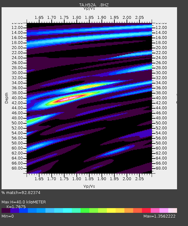
H52A Wyevale, ON, CAN - Earthquake Result Viewer
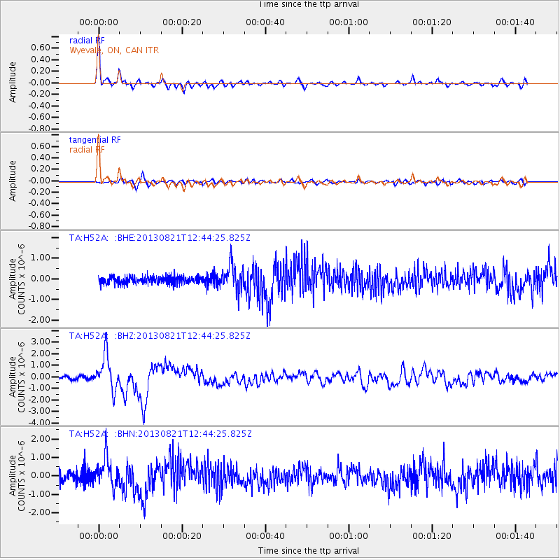
Earthquake location: Near Coast Of Guerrero, Mexico
Earthquake latitude/longitude: 16.9/-99.5
Earthquake time(UTC): 2013/08/21 (233) 12:38:29 GMT
Earthquake Depth: 21 km
Earthquake Magnitude: 6.2 MWW, 6.2 MWW, 6.2 MWB, 6.2 MWC
Earthquake Catalog/Contributor: NEIC PDE/NEIC COMCAT
Network: TA USArray Transportable Network (new EarthScope stations)
Station: H52A Wyevale, ON, CAN
Lat/Lon: 44.64 N/79.89 W
Elevation: 209 m
Distance: 32.2 deg
Az: 26.695 deg
Baz: 217.052 deg
Ray Param: 0.07871896
Estimated Moho Depth: 40.0 km
Estimated Crust Vp/Vs: 1.77
Assumed Crust Vp: 6.577 km/s
Estimated Crust Vs: 3.721 km/s
Estimated Crust Poisson's Ratio: 0.26
Radial Match: 92.82374 %
Radial Bump: 359
Transverse Match: 75.50348 %
Transverse Bump: 400
SOD ConfigId: 626651
Insert Time: 2014-04-18 02:09:17.782 +0000
GWidth: 2.5
Max Bumps: 400
Tol: 0.001

Signal To Noise

ChannelStoNSTALTA
TA:H52A: :BHZ:20130821T12:44:25.825Z14.6067821.5622411E-61.0695314E-7
TA:H52A: :BHN:20130821T12:44:25.825Z3.00054177.837821E-72.6121356E-7
TA:H52A: :BHE:20130821T12:44:25.825Z3.70846656.233821E-71.68097E-7
Arrivals
Ps5.1 SECOND
PpPs15 SECOND
PsPs/PpSs21 SECOND