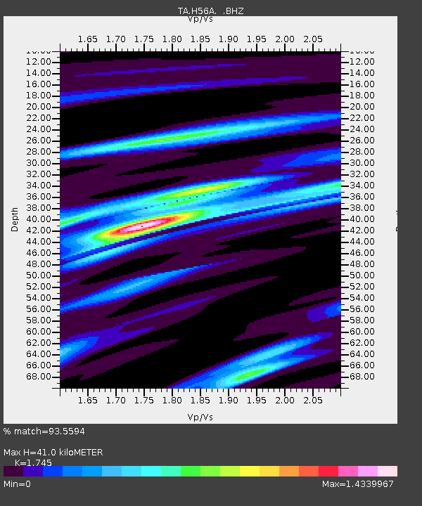
H56A Elgin, ON, CAN - Earthquake Result Viewer

Earthquake location: Near Coast Of Guerrero, Mexico
Earthquake latitude/longitude: 16.9/-99.5
Earthquake time(UTC): 2013/08/21 (233) 12:38:29 GMT
Earthquake Depth: 21 km
Earthquake Magnitude: 6.2 MWW, 6.2 MWW, 6.2 MWB, 6.2 MWC
Earthquake Catalog/Contributor: NEIC PDE/NEIC COMCAT
Network: TA USArray Transportable Network (new EarthScope stations)
Station: H56A Elgin, ON, CAN
Lat/Lon: 44.59 N/76.26 W
Elevation: 137 m
Distance: 33.9 deg
Az: 30.401 deg
Baz: 222.7 deg
Ray Param: 0.077992976
Estimated Moho Depth: 41.0 km
Estimated Crust Vp/Vs: 1.75
Assumed Crust Vp: 6.577 km/s
Estimated Crust Vs: 3.769 km/s
Estimated Crust Poisson's Ratio: 0.26
Radial Match: 93.5594 %
Radial Bump: 302
Transverse Match: 73.72731 %
Transverse Bump: 400
SOD ConfigId: 626651
Insert Time: 2014-04-18 02:09:22.239 +0000
GWidth: 2.5
Max Bumps: 400
Tol: 0.001

Signal To Noise

ChannelStoNSTALTA
TA:H56A: :BHZ:20130821T12:44:39.974994Z24.601051.6575655E-66.737783E-8
TA:H56A: :BHN:20130821T12:44:39.974994Z7.9310758.458774E-71.06653566E-7
TA:H56A: :BHE:20130821T12:44:39.974994Z11.8628918.4798245E-77.1481935E-8
Arrivals
Ps5.0 SECOND
PpPs16 SECOND
PsPs/PpSs21 SECOND