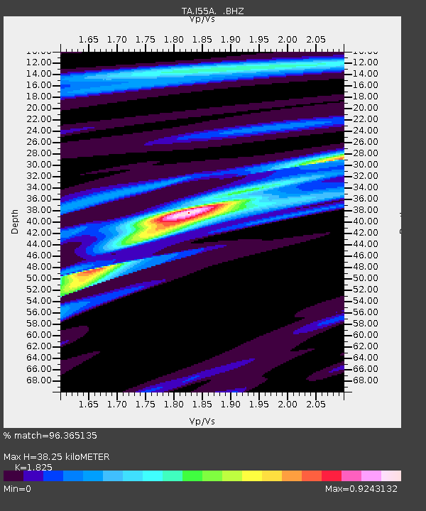
I55A Frankford, ON, CAN - Earthquake Result Viewer
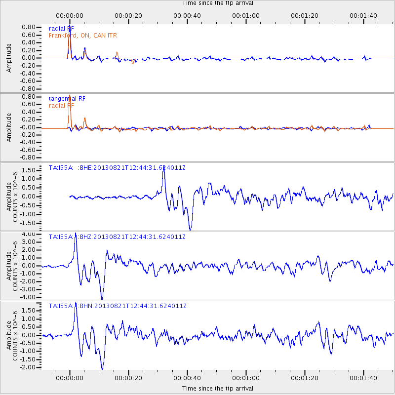
Earthquake location: Near Coast Of Guerrero, Mexico
Earthquake latitude/longitude: 16.9/-99.5
Earthquake time(UTC): 2013/08/21 (233) 12:38:29 GMT
Earthquake Depth: 21 km
Earthquake Magnitude: 6.2 MWW, 6.2 MWW, 6.2 MWB, 6.2 MWC
Earthquake Catalog/Contributor: NEIC PDE/NEIC COMCAT
Network: TA USArray Transportable Network (new EarthScope stations)
Station: I55A Frankford, ON, CAN
Lat/Lon: 44.22 N/77.68 W
Elevation: 132 m
Distance: 32.9 deg
Az: 29.477 deg
Baz: 220.936 deg
Ray Param: 0.07843547
Estimated Moho Depth: 38.25 km
Estimated Crust Vp/Vs: 1.83
Assumed Crust Vp: 6.577 km/s
Estimated Crust Vs: 3.604 km/s
Estimated Crust Poisson's Ratio: 0.29
Radial Match: 96.365135 %
Radial Bump: 234
Transverse Match: 74.63248 %
Transverse Bump: 400
SOD ConfigId: 626651
Insert Time: 2014-04-18 02:09:57.994 +0000
GWidth: 2.5
Max Bumps: 400
Tol: 0.001

Signal To Noise

ChannelStoNSTALTA
TA:I55A: :BHZ:20130821T12:44:31.624011Z16.6942541.7394573E-61.0419497E-7
TA:I55A: :BHN:20130821T12:44:31.624011Z11.3563288.964525E-77.893859E-8
TA:I55A: :BHE:20130821T12:44:31.624011Z14.4448826.785119E-74.6972474E-8
Arrivals
Ps5.2 SECOND
PpPs15 SECOND
PsPs/PpSs20 SECOND