K55A Perry, NY, USA - Earthquake Result Viewer
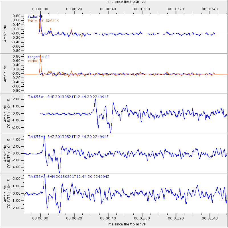
Earthquake location: Near Coast Of Guerrero, Mexico
Earthquake latitude/longitude: 16.9/-99.5
Earthquake time(UTC): 2013/08/21 (233) 12:38:29 GMT
Earthquake Depth: 21 km
Earthquake Magnitude: 6.2 MWW, 6.2 MWW, 6.2 MWB, 6.2 MWC
Earthquake Catalog/Contributor: NEIC PDE/NEIC COMCAT
Network: TA USArray Transportable Network (new EarthScope stations)
Station: K55A Perry, NY, USA
Lat/Lon: 42.73 N/78.07 W
Elevation: 482 m
Distance: 31.6 deg
Az: 30.924 deg
Baz: 221.895 deg
Ray Param: 0.07899039
Estimated Moho Depth: 49.75 km
Estimated Crust Vp/Vs: 1.60
Assumed Crust Vp: 6.419 km/s
Estimated Crust Vs: 4.012 km/s
Estimated Crust Poisson's Ratio: 0.18
Radial Match: 94.85432 %
Radial Bump: 304
Transverse Match: 79.343376 %
Transverse Bump: 400
SOD ConfigId: 626651
Insert Time: 2014-04-18 02:10:38.967 +0000
GWidth: 2.5
Max Bumps: 400
Tol: 0.001

Signal To Noise

ChannelStoNSTALTA
TA:K55A: :BHZ:20130821T12:44:20.224994Z24.7990842.26641E-69.139088E-8
TA:K55A: :BHN:20130821T12:44:20.224994Z13.9925021.1805603E-68.437092E-8
TA:K55A: :BHE:20130821T12:44:20.224994Z16.6017361.0395395E-66.2616316E-8
Arrivals
Ps5.1 SECOND
PpPs18 SECOND
PsPs/PpSs24 SECOND