L56A Greenwood, NY, USA - Earthquake Result Viewer
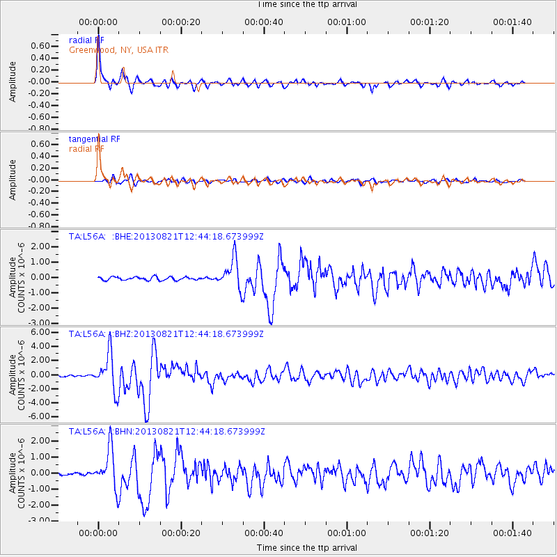
Earthquake location: Near Coast Of Guerrero, Mexico
Earthquake latitude/longitude: 16.9/-99.5
Earthquake time(UTC): 2013/08/21 (233) 12:38:29 GMT
Earthquake Depth: 21 km
Earthquake Magnitude: 6.2 MWW, 6.2 MWW, 6.2 MWB, 6.2 MWC
Earthquake Catalog/Contributor: NEIC PDE/NEIC COMCAT
Network: TA USArray Transportable Network (new EarthScope stations)
Station: L56A Greenwood, NY, USA
Lat/Lon: 42.14 N/77.56 W
Elevation: 688 m
Distance: 31.4 deg
Az: 32.222 deg
Baz: 223.345 deg
Ray Param: 0.07906284
Estimated Moho Depth: 45.0 km
Estimated Crust Vp/Vs: 1.75
Assumed Crust Vp: 6.476 km/s
Estimated Crust Vs: 3.69 km/s
Estimated Crust Poisson's Ratio: 0.26
Radial Match: 94.60085 %
Radial Bump: 400
Transverse Match: 78.7588 %
Transverse Bump: 400
SOD ConfigId: 626651
Insert Time: 2014-04-18 02:10:58.158 +0000
GWidth: 2.5
Max Bumps: 400
Tol: 0.001

Signal To Noise

ChannelStoNSTALTA
TA:L56A: :BHZ:20130821T12:44:18.673999Z25.6687432.7770182E-61.0818676E-7
TA:L56A: :BHN:20130821T12:44:18.673999Z14.2363441.2866502E-69.0377846E-8
TA:L56A: :BHE:20130821T12:44:18.673999Z9.8260471.0308145E-61.0490632E-7
Arrivals
Ps5.7 SECOND
PpPs18 SECOND
PsPs/PpSs23 SECOND