You are here: Home > Network List > TA - USArray Transportable Network (new EarthScope stations) Stations List
> Station M58A Price's Panorama, Nuncy Valley, PA, USA > Earthquake Result Viewer
M58A Price's Panorama, Nuncy Valley, PA, USA - Earthquake Result Viewer
| Earthquake location: |
Near Coast Of Guerrero, Mexico |
| Earthquake latitude/longitude: |
16.9/-99.5 |
| Earthquake time(UTC): |
2013/08/21 (233) 12:38:29 GMT |
| Earthquake Depth: |
21 km |
| Earthquake Magnitude: |
6.2 MWW, 6.2 MWW, 6.2 MWB, 6.2 MWC |
| Earthquake Catalog/Contributor: |
NEIC PDE/NEIC COMCAT |
|
| Network: |
TA USArray Transportable Network (new EarthScope stations) |
| Station: |
M58A Price's Panorama, Nuncy Valley, PA, USA |
| Lat/Lon: |
41.37 N/76.46 W |
| Elevation: |
529 m |
|
| Distance: |
31.4 deg |
| Az: |
34.374 deg |
| Baz: |
225.91 deg |
| Ray Param: |
0.07905201 |
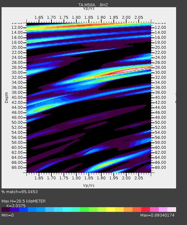
| Estimated Moho Depth: |
28.5 km |
| Estimated Crust Vp/Vs: |
2.04 |
| Assumed Crust Vp: |
6.121 km/s |
| Estimated Crust Vs: |
3.004 km/s |
| Estimated Crust Poisson's Ratio: |
0.34 |
|
| Radial Match: |
95.0453 % |
| Radial Bump: |
400 |
| Transverse Match: |
80.597046 % |
| Transverse Bump: |
400 |
| SOD ConfigId: |
626651 |
| Insert Time: |
2014-04-18 02:11:18.462 +0000 |
| GWidth: |
2.5 |
| Max Bumps: |
400 |
| Tol: |
0.001 |
|

Signal To Noise
| Channel | StoN | STA | LTA |
| TA:M58A: :BHZ:20130821T12:44:18.974994Z | 20.925615 | 2.2181262E-6 | 1.0600052E-7 |
| TA:M58A: :BHN:20130821T12:44:18.974994Z | 10.106623 | 7.440609E-7 | 7.362112E-8 |
| TA:M58A: :BHE:20130821T12:44:18.974994Z | 12.629913 | 8.1222106E-7 | 6.430931E-8 |
| Arrivals |
| Ps | 5.1 SECOND |
| PpPs | 13 SECOND |
| PsPs/PpSs | 18 SECOND |


