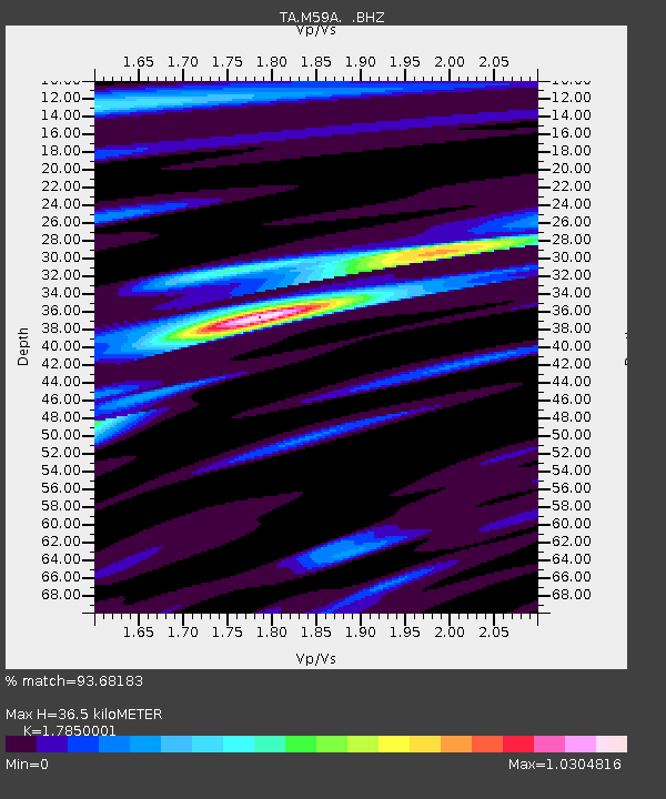
M59A Waymart, PA, USA - Earthquake Result Viewer
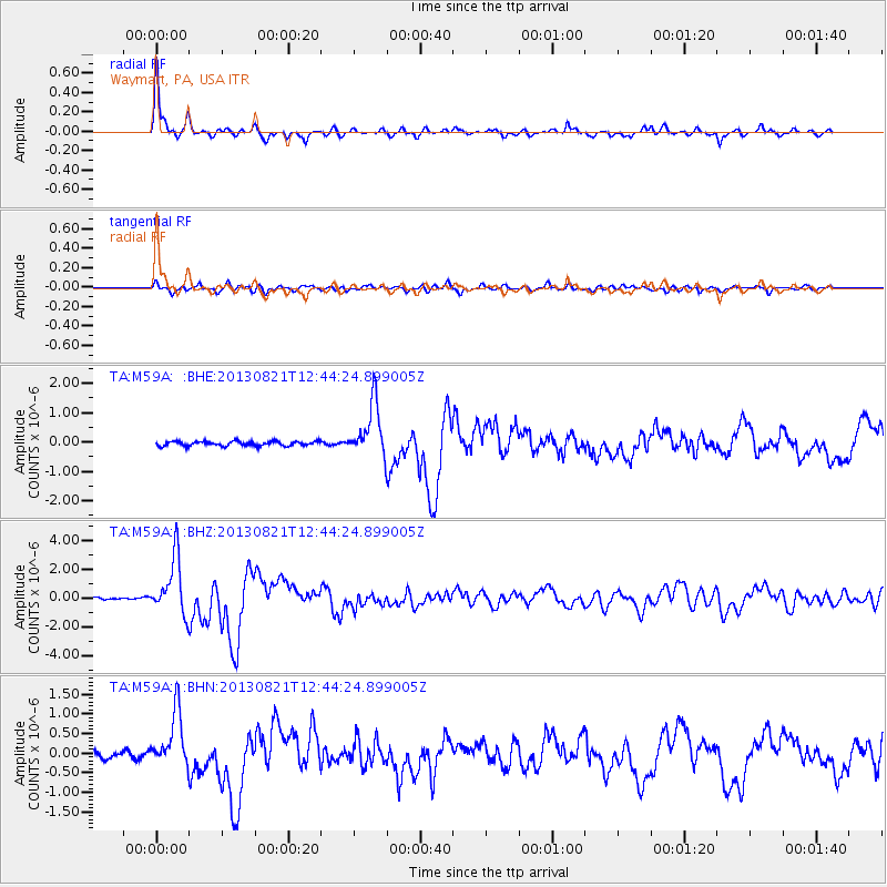
Earthquake location: Near Coast Of Guerrero, Mexico
Earthquake latitude/longitude: 16.9/-99.5
Earthquake time(UTC): 2013/08/21 (233) 12:38:29 GMT
Earthquake Depth: 21 km
Earthquake Magnitude: 6.2 MWW, 6.2 MWW, 6.2 MWB, 6.2 MWC
Earthquake Catalog/Contributor: NEIC PDE/NEIC COMCAT
Network: TA USArray Transportable Network (new EarthScope stations)
Station: M59A Waymart, PA, USA
Lat/Lon: 41.54 N/75.43 W
Elevation: 471 m
Distance: 32.1 deg
Az: 35.149 deg
Baz: 227.247 deg
Ray Param: 0.07876398
Estimated Moho Depth: 36.5 km
Estimated Crust Vp/Vs: 1.79
Assumed Crust Vp: 6.283 km/s
Estimated Crust Vs: 3.52 km/s
Estimated Crust Poisson's Ratio: 0.27
Radial Match: 93.68183 %
Radial Bump: 340
Transverse Match: 79.94716 %
Transverse Bump: 400
SOD ConfigId: 626651
Insert Time: 2014-04-18 02:11:25.061 +0000
GWidth: 2.5
Max Bumps: 400
Tol: 0.001

Signal To Noise

ChannelStoNSTALTA
TA:M59A: :BHZ:20130821T12:44:24.899005Z17.2804761.9565375E-61.1322244E-7
TA:M59A: :BHN:20130821T12:44:24.899005Z8.6047517.0583513E-78.202854E-8
TA:M59A: :BHE:20130821T12:44:24.899005Z12.26489459.125259E-77.440144E-8
Arrivals
Ps4.9 SECOND
PpPs15 SECOND
PsPs/PpSs20 SECOND