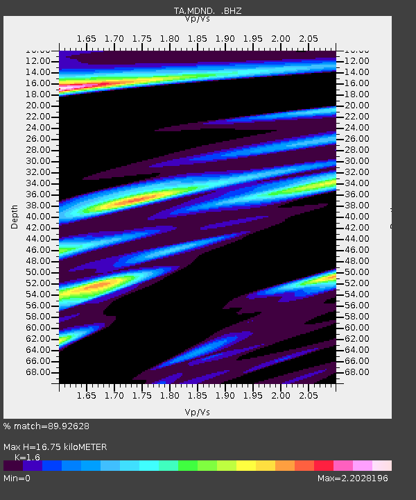
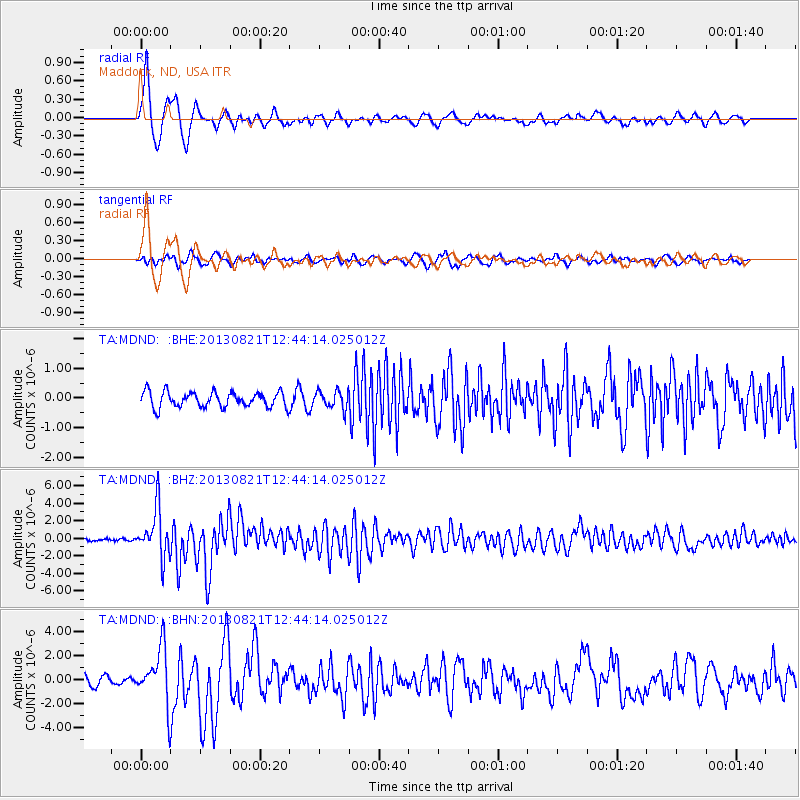
MDND Maddock, ND, USA - Earthquake Result Viewer

Earthquake location: Near Coast Of Guerrero, Mexico
Earthquake latitude/longitude: 16.9/-99.5
Earthquake time(UTC): 2013/08/21 (233) 12:38:29 GMT
Earthquake Depth: 21 km
Earthquake Magnitude: 6.2 MWW, 6.2 MWW, 6.2 MWB, 6.2 MWC
Earthquake Catalog/Contributor: NEIC PDE/NEIC COMCAT
Network: TA USArray Transportable Network (new EarthScope stations)
Station: MDND Maddock, ND, USA
Lat/Lon: 47.85 N/99.60 W
Elevation: 479 m
Distance: 30.9 deg
Az: 359.862 deg
Baz: 179.804 deg
Ray Param: 0.079200946
Estimated Moho Depth: 16.75 km
Estimated Crust Vp/Vs: 1.60
Assumed Crust Vp: 6.53 km/s
Estimated Crust Vs: 4.082 km/s
Estimated Crust Poisson's Ratio: 0.18
Radial Match: 89.92628 %
Radial Bump: 381
Transverse Match: 77.66368 %
Transverse Bump: 400
SOD ConfigId: 626651
Insert Time: 2014-04-18 02:11:30.025 +0000
GWidth: 2.5
Max Bumps: 400
Tol: 0.001

Signal To Noise

ChannelStoNSTALTA
TA:MDND: :BHZ:20130821T12:44:14.025012Z26.9240592.736739E-61.016466E-7
TA:MDND: :BHN:20130821T12:44:14.025012Z6.78489452.2884665E-63.3728844E-7
TA:MDND: :BHE:20130821T12:44:14.025012Z1.14718042.9646336E-72.5842783E-7
Arrivals
Ps1.7 SECOND
PpPs6.1 SECOND
PsPs/PpSs7.8 SECOND