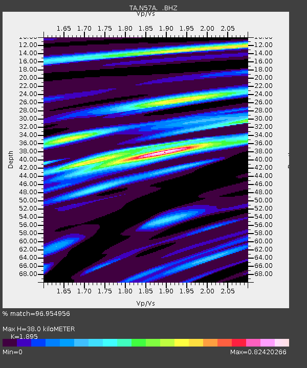
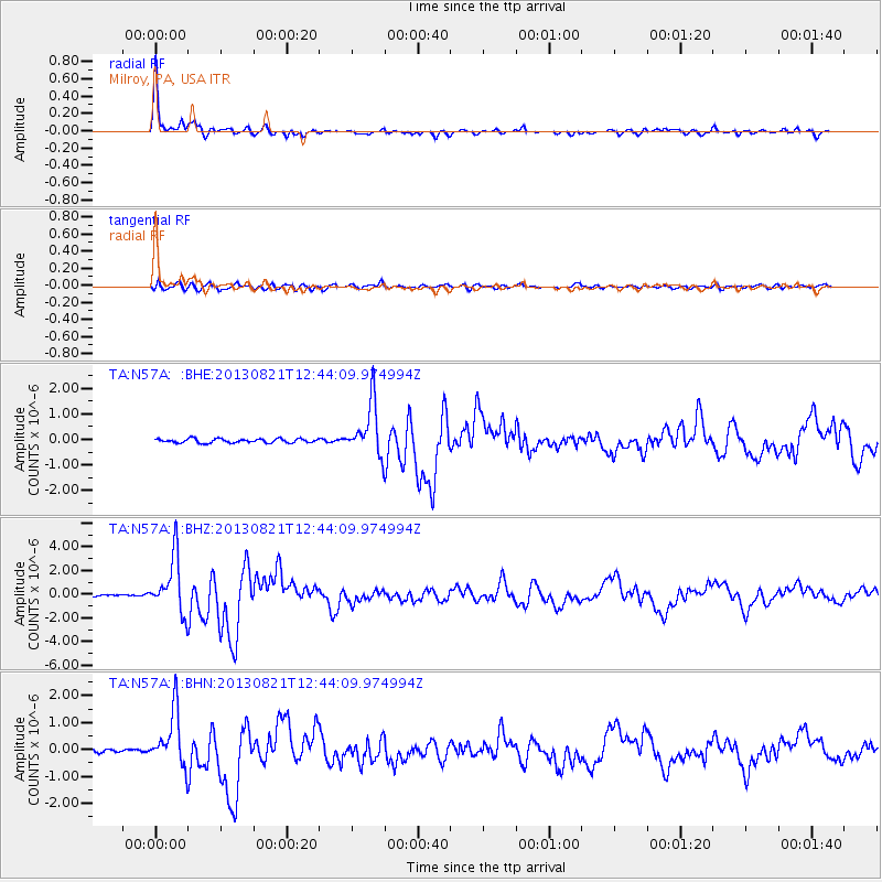
N57A Milroy, PA, USA - Earthquake Result Viewer

Earthquake location: Near Coast Of Guerrero, Mexico
Earthquake latitude/longitude: 16.9/-99.5
Earthquake time(UTC): 2013/08/21 (233) 12:38:29 GMT
Earthquake Depth: 21 km
Earthquake Magnitude: 6.2 MWW, 6.2 MWW, 6.2 MWB, 6.2 MWC
Earthquake Catalog/Contributor: NEIC PDE/NEIC COMCAT
Network: TA USArray Transportable Network (new EarthScope stations)
Station: N57A Milroy, PA, USA
Lat/Lon: 40.76 N/77.55 W
Elevation: 306 m
Distance: 30.4 deg
Az: 34.102 deg
Baz: 224.963 deg
Ray Param: 0.07932176
Estimated Moho Depth: 38.0 km
Estimated Crust Vp/Vs: 1.89
Assumed Crust Vp: 6.121 km/s
Estimated Crust Vs: 3.23 km/s
Estimated Crust Poisson's Ratio: 0.31
Radial Match: 96.954956 %
Radial Bump: 290
Transverse Match: 83.55015 %
Transverse Bump: 400
SOD ConfigId: 626651
Insert Time: 2014-04-18 02:11:43.861 +0000
GWidth: 2.5
Max Bumps: 400
Tol: 0.001

Signal To Noise

ChannelStoNSTALTA
TA:N57A: :BHZ:20130821T12:44:09.974994Z25.7445742.334079E-69.066295E-8
TA:N57A: :BHN:20130821T12:44:09.974994Z14.004761.0175875E-67.2660114E-8
TA:N57A: :BHE:20130821T12:44:09.974994Z13.0359311.025524E-67.8669025E-8
Arrivals
Ps5.9 SECOND
PpPs17 SECOND
PsPs/PpSs23 SECOND