O58A Lewisberry, PA, USA - Earthquake Result Viewer
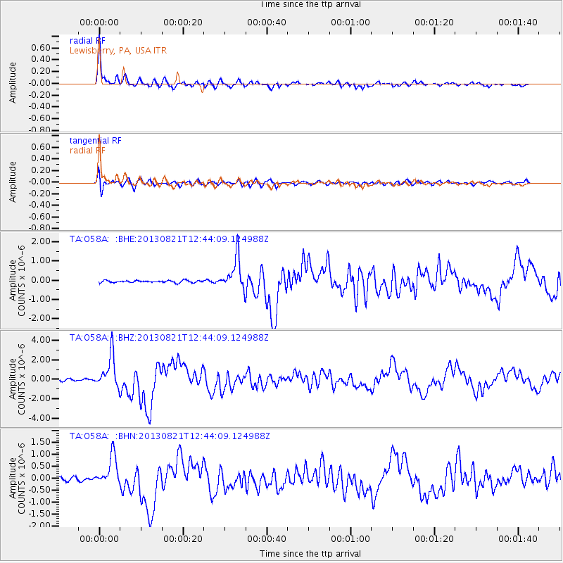
Earthquake location: Near Coast Of Guerrero, Mexico
Earthquake latitude/longitude: 16.9/-99.5
Earthquake time(UTC): 2013/08/21 (233) 12:38:29 GMT
Earthquake Depth: 21 km
Earthquake Magnitude: 6.2 MWW, 6.2 MWW, 6.2 MWB, 6.2 MWC
Earthquake Catalog/Contributor: NEIC PDE/NEIC COMCAT
Network: TA USArray Transportable Network (new EarthScope stations)
Station: O58A Lewisberry, PA, USA
Lat/Lon: 40.12 N/76.92 W
Elevation: 321 m
Distance: 30.3 deg
Az: 35.658 deg
Baz: 226.712 deg
Ray Param: 0.079347044
Estimated Moho Depth: 33.5 km
Estimated Crust Vp/Vs: 2.09
Assumed Crust Vp: 6.121 km/s
Estimated Crust Vs: 2.925 km/s
Estimated Crust Poisson's Ratio: 0.35
Radial Match: 94.44702 %
Radial Bump: 400
Transverse Match: 74.91218 %
Transverse Bump: 400
SOD ConfigId: 626651
Insert Time: 2014-04-18 02:12:04.173 +0000
GWidth: 2.5
Max Bumps: 400
Tol: 0.001

Signal To Noise

ChannelStoNSTALTA
TA:O58A: :BHZ:20130821T12:44:09.124988Z17.706241.7360425E-69.804693E-8
TA:O58A: :BHN:20130821T12:44:09.124988Z9.7647416.566507E-76.724712E-8
TA:O58A: :BHE:20130821T12:44:09.124988Z16.334118.6677954E-75.3065612E-8
Arrivals
Ps6.4 SECOND
PpPs16 SECOND
PsPs/PpSs22 SECOND