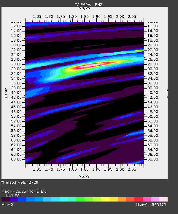
P60A Greenville, DE, USA - Earthquake Result Viewer

Earthquake location: Near Coast Of Guerrero, Mexico
Earthquake latitude/longitude: 16.9/-99.5
Earthquake time(UTC): 2013/08/21 (233) 12:38:29 GMT
Earthquake Depth: 21 km
Earthquake Magnitude: 6.2 MWW, 6.2 MWW, 6.2 MWB, 6.2 MWC
Earthquake Catalog/Contributor: NEIC PDE/NEIC COMCAT
Network: TA USArray Transportable Network (new EarthScope stations)
Station: P60A Greenville, DE, USA
Lat/Lon: 39.81 N/75.64 W
Elevation: 105 m
Distance: 30.9 deg
Az: 37.416 deg
Baz: 229.048 deg
Ray Param: 0.07920919
Estimated Moho Depth: 28.25 km
Estimated Crust Vp/Vs: 1.88
Assumed Crust Vp: 6.287 km/s
Estimated Crust Vs: 3.344 km/s
Estimated Crust Poisson's Ratio: 0.30
Radial Match: 96.42729 %
Radial Bump: 297
Transverse Match: 84.1504 %
Transverse Bump: 400
SOD ConfigId: 626651
Insert Time: 2014-04-18 02:12:22.016 +0000
GWidth: 2.5
Max Bumps: 400
Tol: 0.001

Signal To Noise

ChannelStoNSTALTA
TA:P60A: :BHZ:20130821T12:44:13.749988Z24.0911051.6880493E-67.00694E-8
TA:P60A: :BHN:20130821T12:44:13.749988Z12.13608558.738267E-77.200235E-8
TA:P60A: :BHE:20130821T12:44:13.749988Z10.5871477.750375E-77.3205506E-8
Arrivals
Ps4.2 SECOND
PpPs12 SECOND
PsPs/PpSs16 SECOND