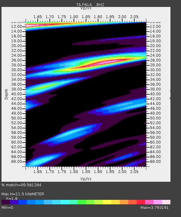
P61A Hammonton, NJ, USA - Earthquake Result Viewer
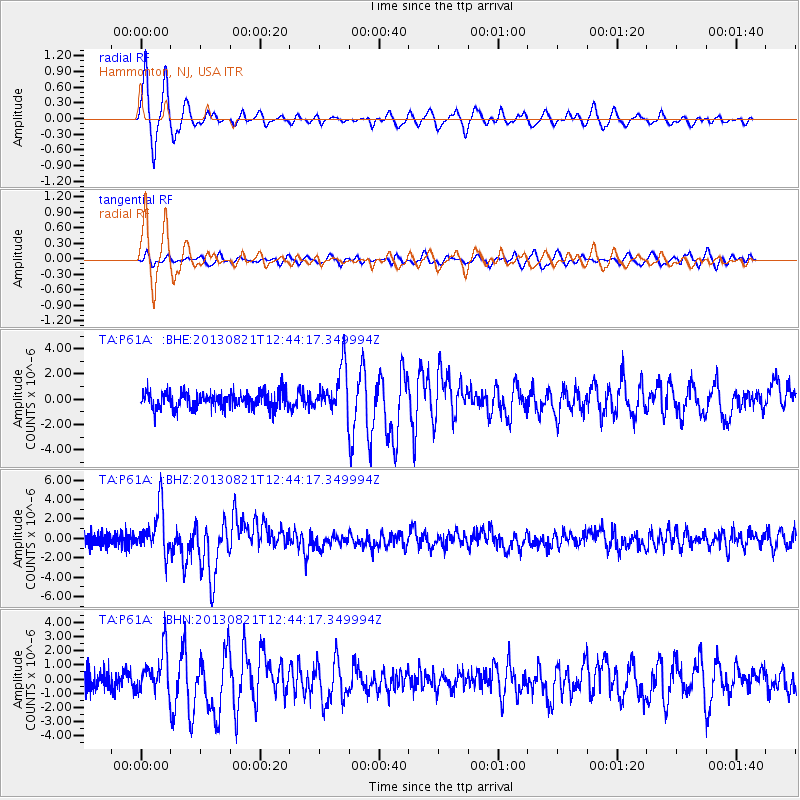
Earthquake location: Near Coast Of Guerrero, Mexico
Earthquake latitude/longitude: 16.9/-99.5
Earthquake time(UTC): 2013/08/21 (233) 12:38:29 GMT
Earthquake Depth: 21 km
Earthquake Magnitude: 6.2 MWW, 6.2 MWW, 6.2 MWB, 6.2 MWC
Earthquake Catalog/Contributor: NEIC PDE/NEIC COMCAT
Network: TA USArray Transportable Network (new EarthScope stations)
Station: P61A Hammonton, NJ, USA
Lat/Lon: 39.67 N/74.79 W
Elevation: 22 m
Distance: 31.3 deg
Az: 38.435 deg
Baz: 230.458 deg
Ray Param: 0.079102114
Estimated Moho Depth: 11.5 km
Estimated Crust Vp/Vs: 1.60
Assumed Crust Vp: 6.287 km/s
Estimated Crust Vs: 3.93 km/s
Estimated Crust Poisson's Ratio: 0.18
Radial Match: 89.561264 %
Radial Bump: 352
Transverse Match: 64.27214 %
Transverse Bump: 400
SOD ConfigId: 626651
Insert Time: 2014-04-18 02:12:24.394 +0000
GWidth: 2.5
Max Bumps: 400
Tol: 0.001

Signal To Noise

ChannelStoNSTALTA
TA:P61A: :BHZ:20130821T12:44:17.349994Z3.96263382.3067219E-65.8211833E-7
TA:P61A: :BHN:20130821T12:44:17.349994Z2.6349341.4845064E-65.633941E-7
TA:P61A: :BHE:20130821T12:44:17.349994Z2.66938611.7550352E-66.5746775E-7
Arrivals
Ps1.2 SECOND
PpPs4.4 SECOND
PsPs/PpSs5.6 SECOND