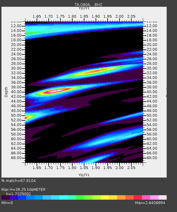
Q60A Greensboro, MD, USA - Earthquake Result Viewer
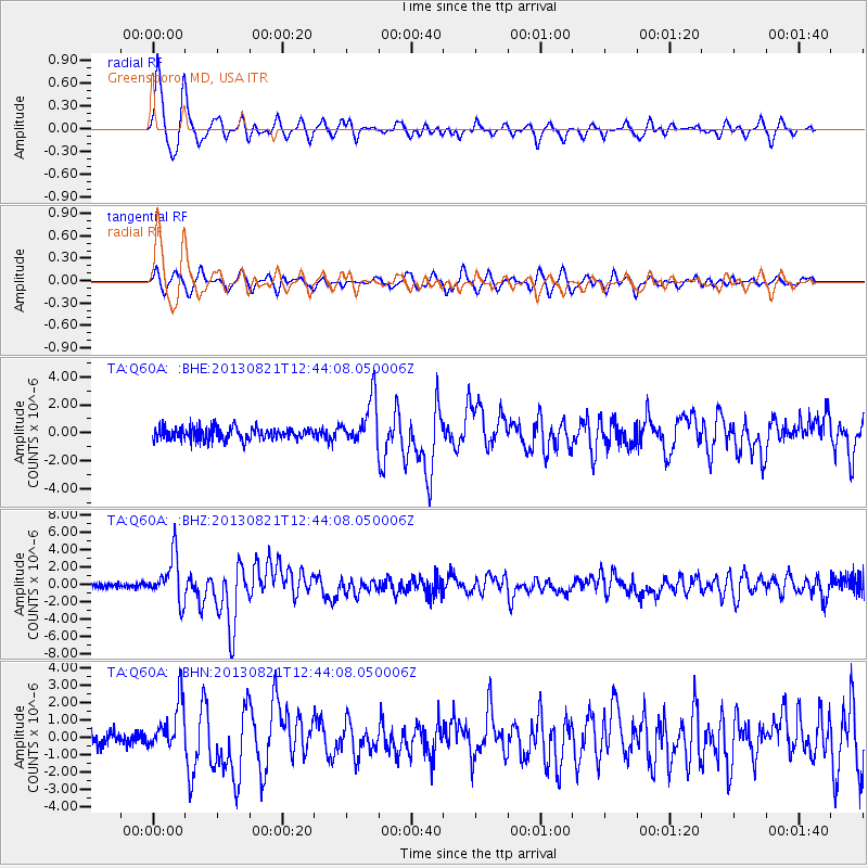
Earthquake location: Near Coast Of Guerrero, Mexico
Earthquake latitude/longitude: 16.9/-99.5
Earthquake time(UTC): 2013/08/21 (233) 12:38:29 GMT
Earthquake Depth: 21 km
Earthquake Magnitude: 6.2 MWW, 6.2 MWW, 6.2 MWB, 6.2 MWC
Earthquake Catalog/Contributor: NEIC PDE/NEIC COMCAT
Network: TA USArray Transportable Network (new EarthScope stations)
Station: Q60A Greensboro, MD, USA
Lat/Lon: 39.00 N/75.84 W
Elevation: 14 m
Distance: 30.2 deg
Az: 38.419 deg
Baz: 229.781 deg
Ray Param: 0.07937938
Estimated Moho Depth: 39.25 km
Estimated Crust Vp/Vs: 1.73
Assumed Crust Vp: 6.287 km/s
Estimated Crust Vs: 3.629 km/s
Estimated Crust Poisson's Ratio: 0.25
Radial Match: 87.8104 %
Radial Bump: 375
Transverse Match: 75.4199 %
Transverse Bump: 400
SOD ConfigId: 626651
Insert Time: 2014-04-18 02:12:29.366 +0000
GWidth: 2.5
Max Bumps: 400
Tol: 0.001

Signal To Noise

ChannelStoNSTALTA
TA:Q60A: :BHZ:20130821T12:44:08.050006Z6.10746572.5847146E-64.2320576E-7
TA:Q60A: :BHN:20130821T12:44:08.050006Z3.17765331.3730363E-64.320913E-7
TA:Q60A: :BHE:20130821T12:44:08.050006Z3.67293861.6467155E-64.4833735E-7
Arrivals
Ps4.9 SECOND
PpPs16 SECOND
PsPs/PpSs21 SECOND