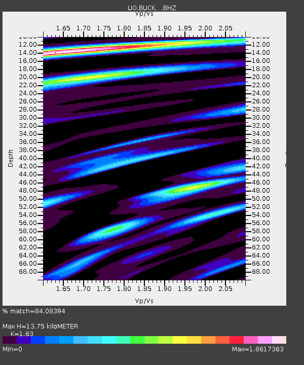
BUCK Buck Mountain, OR - Earthquake Result Viewer

Earthquake location: Near Coast Of Guerrero, Mexico
Earthquake latitude/longitude: 16.9/-99.5
Earthquake time(UTC): 2013/08/21 (233) 12:38:29 GMT
Earthquake Depth: 21 km
Earthquake Magnitude: 6.2 MWW, 6.2 MWW, 6.2 MWB, 6.2 MWC
Earthquake Catalog/Contributor: NEIC PDE/NEIC COMCAT
Network: UO University of Oregon Regional Network
Station: BUCK Buck Mountain, OR
Lat/Lon: 44.20 N/122.99 W
Elevation: 964 m
Distance: 33.7 deg
Az: 328.878 deg
Baz: 136.526 deg
Ray Param: 0.07806971
Estimated Moho Depth: 13.75 km
Estimated Crust Vp/Vs: 1.63
Assumed Crust Vp: 6.566 km/s
Estimated Crust Vs: 4.028 km/s
Estimated Crust Poisson's Ratio: 0.20
Radial Match: 84.08394 %
Radial Bump: 400
Transverse Match: 74.75214 %
Transverse Bump: 400
SOD ConfigId: 626651
Insert Time: 2014-04-18 02:12:53.660 +0000
GWidth: 2.5
Max Bumps: 400
Tol: 0.001

Signal To Noise

ChannelStoNSTALTA
UO:BUCK: :BHZ:20130821T12:44:38.525012Z4.097761.5462314E-63.773357E-7
UO:BUCK: :BHN:20130821T12:44:38.525012Z0.92860173.8623102E-74.1592756E-7
UO:BUCK: :BHE:20130821T12:44:38.525012Z3.10415841.1813736E-63.8057775E-7
Arrivals
Ps1.4 SECOND
PpPs5.0 SECOND
PsPs/PpSs6.5 SECOND