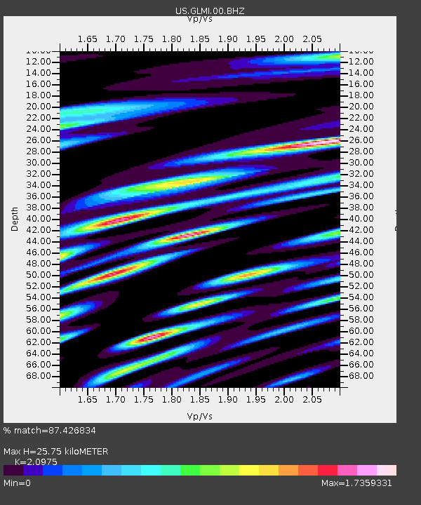
GLMI Grayling, Michigan, USA - Earthquake Result Viewer

Earthquake location: Near Coast Of Guerrero, Mexico
Earthquake latitude/longitude: 16.9/-99.5
Earthquake time(UTC): 2013/08/21 (233) 12:38:29 GMT
Earthquake Depth: 21 km
Earthquake Magnitude: 6.2 MWW, 6.2 MWW, 6.2 MWB, 6.2 MWC
Earthquake Catalog/Contributor: NEIC PDE/NEIC COMCAT
Network: US United States National Seismic Network
Station: GLMI Grayling, Michigan, USA
Lat/Lon: 44.82 N/84.62 W
Elevation: 387 m
Distance: 30.5 deg
Az: 21.076 deg
Baz: 208.936 deg
Ray Param: 0.07929048
Estimated Moho Depth: 25.75 km
Estimated Crust Vp/Vs: 2.10
Assumed Crust Vp: 6.483 km/s
Estimated Crust Vs: 3.091 km/s
Estimated Crust Poisson's Ratio: 0.35
Radial Match: 87.426834 %
Radial Bump: 400
Transverse Match: 69.13006 %
Transverse Bump: 400
SOD ConfigId: 626651
Insert Time: 2014-04-18 02:13:34.695 +0000
GWidth: 2.5
Max Bumps: 400
Tol: 0.001

Signal To Noise

ChannelStoNSTALTA
US:GLMI:00:BHZ:20130821T12:44:11.024005Z5.50450752.1952158E-63.9880334E-7
US:GLMI:00:BH1:20130821T12:44:11.024005Z2.76386551.4635546E-65.2953175E-7
US:GLMI:00:BH2:20130821T12:44:11.024005Z2.2314441.1041913E-64.9483265E-7
Arrivals
Ps4.7 SECOND
PpPs11 SECOND
PsPs/PpSs16 SECOND