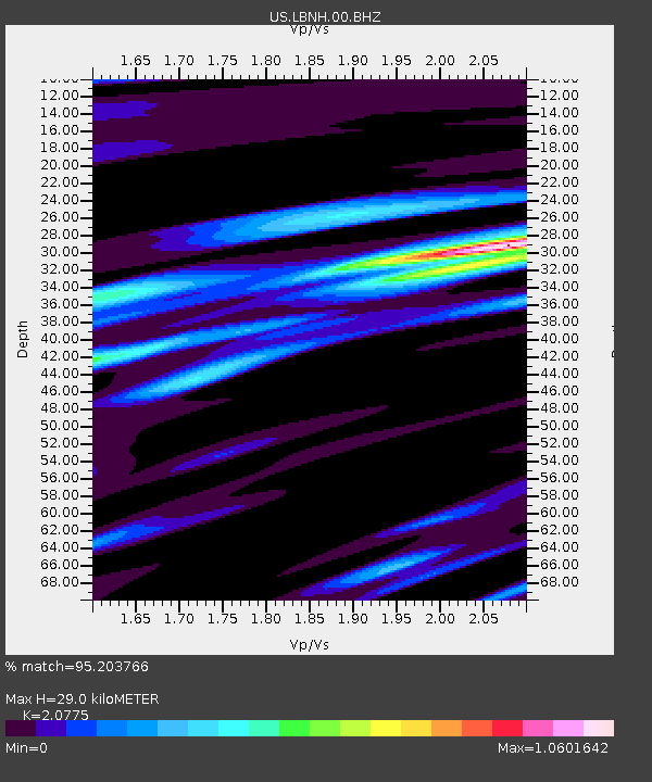
LBNH Lisbon, New Hampshire, USA - Earthquake Result Viewer

Earthquake location: Near Coast Of Guerrero, Mexico
Earthquake latitude/longitude: 16.9/-99.5
Earthquake time(UTC): 2013/08/21 (233) 12:38:29 GMT
Earthquake Depth: 21 km
Earthquake Magnitude: 6.2 MWW, 6.2 MWW, 6.2 MWB, 6.2 MWC
Earthquake Catalog/Contributor: NEIC PDE/NEIC COMCAT
Network: US United States National Seismic Network
Station: LBNH Lisbon, New Hampshire, USA
Lat/Lon: 44.24 N/71.93 W
Elevation: 367 m
Distance: 35.8 deg
Az: 34.624 deg
Baz: 229.19 deg
Ray Param: 0.07697876
Estimated Moho Depth: 29.0 km
Estimated Crust Vp/Vs: 2.08
Assumed Crust Vp: 6.419 km/s
Estimated Crust Vs: 3.09 km/s
Estimated Crust Poisson's Ratio: 0.35
Radial Match: 95.203766 %
Radial Bump: 230
Transverse Match: 77.06775 %
Transverse Bump: 400
SOD ConfigId: 626651
Insert Time: 2014-04-18 02:13:45.325 +0000
GWidth: 2.5
Max Bumps: 400
Tol: 0.001

Signal To Noise

ChannelStoNSTALTA
US:LBNH:00:BHZ:20130821T12:44:57.073993Z20.4781952.259411E-61.1033253E-7
US:LBNH:00:BH1:20130821T12:44:57.073993Z7.9280949.777469E-71.2332686E-7
US:LBNH:00:BH2:20130821T12:44:57.073993Z10.2702161.2147806E-61.18281896E-7
Arrivals
Ps5.2 SECOND
PpPs13 SECOND
PsPs/PpSs18 SECOND