You are here: Home > Network List > US - United States National Seismic Network Stations List
> Station WRAK Wrangell Island, Southeastern Alaska, Alaska, USA > Earthquake Result Viewer
WRAK Wrangell Island, Southeastern Alaska, Alaska, USA - Earthquake Result Viewer
| Earthquake location: |
Near Coast Of Guerrero, Mexico |
| Earthquake latitude/longitude: |
16.9/-99.5 |
| Earthquake time(UTC): |
2013/08/21 (233) 12:38:29 GMT |
| Earthquake Depth: |
21 km |
| Earthquake Magnitude: |
6.2 MWW, 6.2 MWW, 6.2 MWB, 6.2 MWC |
| Earthquake Catalog/Contributor: |
NEIC PDE/NEIC COMCAT |
|
| Network: |
US United States National Seismic Network |
| Station: |
WRAK Wrangell Island, Southeastern Alaska, Alaska, USA |
| Lat/Lon: |
56.42 N/132.35 W |
| Elevation: |
81 m |
|
| Distance: |
46.6 deg |
| Az: |
335.497 deg |
| Baz: |
134.389 deg |
| Ray Param: |
0.0705061 |
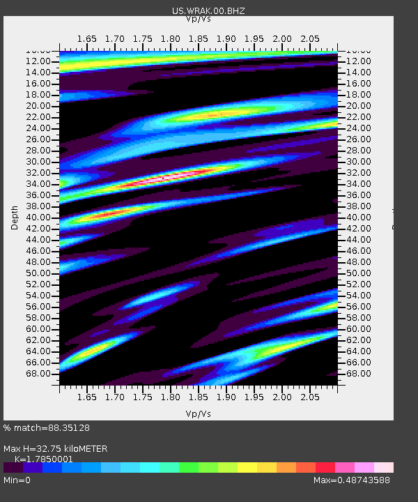
| Estimated Moho Depth: |
32.75 km |
| Estimated Crust Vp/Vs: |
1.79 |
| Assumed Crust Vp: |
6.597 km/s |
| Estimated Crust Vs: |
3.696 km/s |
| Estimated Crust Poisson's Ratio: |
0.27 |
|
| Radial Match: |
88.35128 % |
| Radial Bump: |
400 |
| Transverse Match: |
62.604782 % |
| Transverse Bump: |
400 |
| SOD ConfigId: |
626651 |
| Insert Time: |
2014-04-18 02:14:00.479 +0000 |
| GWidth: |
2.5 |
| Max Bumps: |
400 |
| Tol: |
0.001 |
|
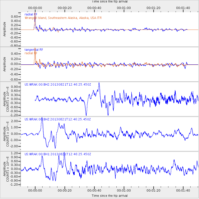
Signal To Noise
| Channel | StoN | STA | LTA |
| US:WRAK:00:BHZ:20130821T12:46:25.450Z | 9.368158 | 9.575357E-7 | 1.0221173E-7 |
| US:WRAK:00:BH1:20130821T12:46:25.450Z | 5.005617 | 3.5805346E-7 | 7.153034E-8 |
| US:WRAK:00:BH2:20130821T12:46:25.450Z | 4.972587 | 4.378525E-7 | 8.8053255E-8 |
| Arrivals |
| Ps | 4.2 SECOND |
| PpPs | 13 SECOND |
| PsPs/PpSs | 17 SECOND |


