You are here: Home > Network List > UW - Pacific Northwest Regional Seismic Network Stations List
> Station LCCR Mulino, OR, USA > Earthquake Result Viewer
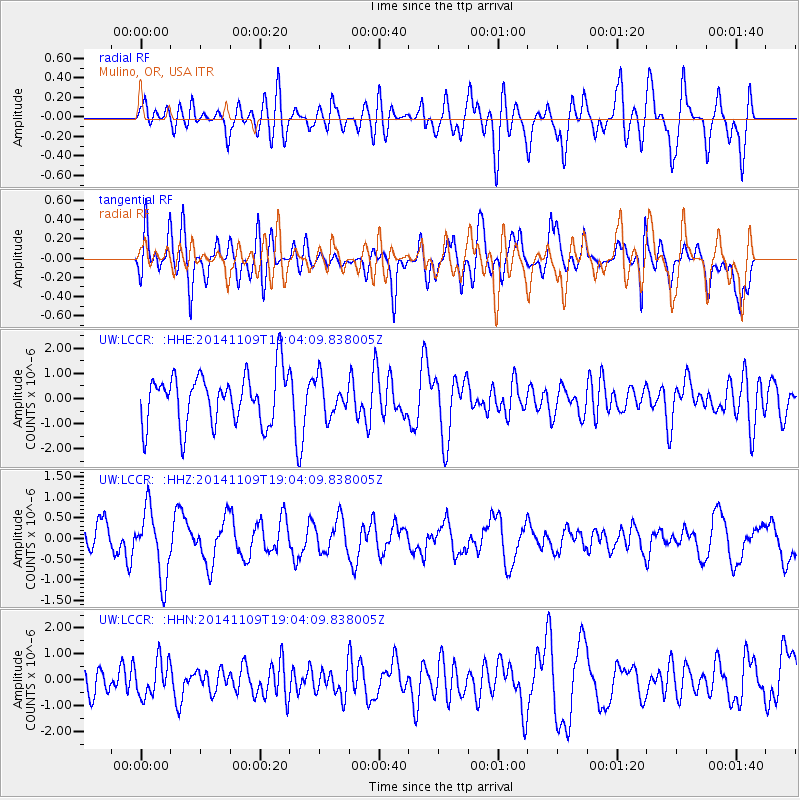
LCCR Mulino, OR, USA - Earthquake Result Viewer
*The percent match for this event was below the threshold and hence no stack was calculated.
| Earthquake location: |
Mariana Islands |
| Earthquake latitude/longitude: |
13.2/144.2 |
| Earthquake time(UTC): |
2014/11/09 (313) 18:52:30 GMT |
| Earthquake Depth: |
138 km |
| Earthquake Magnitude: |
4.6 mb, 4.5 mb |
| Earthquake Catalog/Contributor: |
ISC/ISC |
|
| Network: |
UW Pacific Northwest Regional Seismic Network |
| Station: |
LCCR Mulino, OR, USA |
| Lat/Lon: |
45.21 N/122.48 W |
| Elevation: |
273 m |
|
| Distance: |
83.1 deg |
| Az: |
45.312 deg |
| Baz: |
281.646 deg |
| Ray Param: |
$rayparam |
*The percent match for this event was below the threshold and hence was not used in the summary stack. |
|
| Radial Match: |
48.92044 % |
| Radial Bump: |
400 |
| Transverse Match: |
59.679775 % |
| Transverse Bump: |
400 |
| SOD ConfigId: |
3390531 |
| Insert Time: |
2019-04-14 22:02:06.684 +0000 |
| GWidth: |
2.5 |
| Max Bumps: |
400 |
| Tol: |
0.001 |
|
Signal To Noise
| Channel | StoN | STA | LTA |
| UW:LCCR: :HHZ:20141109T19:04:09.838005Z | 2.1951666 | 8.242199E-7 | 3.7547034E-7 |
| UW:LCCR: :HHN:20141109T19:04:09.838005Z | 1.1115 | 6.9340604E-7 | 6.238471E-7 |
| UW:LCCR: :HHE:20141109T19:04:09.838005Z | 0.70929265 | 7.128547E-7 | 1.005022E-6 |
| Arrivals |
| Ps | |
| PpPs | |
| PsPs/PpSs | |


