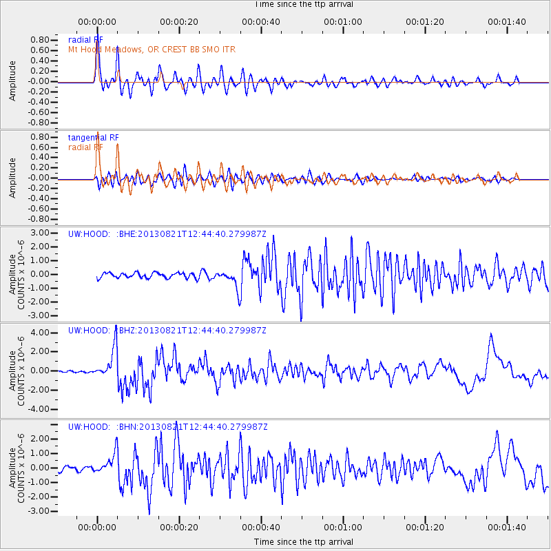
HOOD Mt Hood Meadows, OR CREST BB SMO - Earthquake Result Viewer
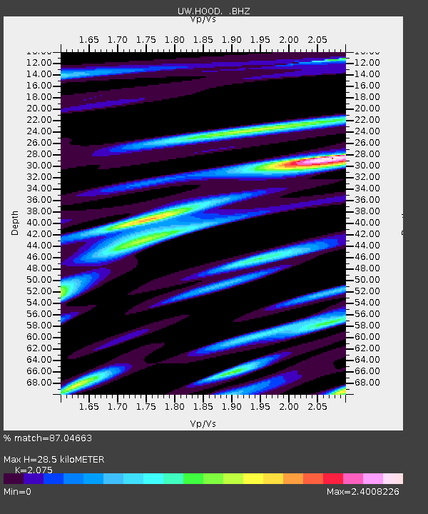
Earthquake location: Near Coast Of Guerrero, Mexico
Earthquake latitude/longitude: 16.9/-99.5
Earthquake time(UTC): 2013/08/21 (233) 12:38:29 GMT
Earthquake Depth: 21 km
Earthquake Magnitude: 6.2 MWW, 6.2 MWW, 6.2 MWB, 6.2 MWC
Earthquake Catalog/Contributor: NEIC PDE/NEIC COMCAT
Network: UW Pacific Northwest Regional Seismic Network
Station: HOOD Mt Hood Meadows, OR CREST BB SMO
Lat/Lon: 45.32 N/121.65 W
Elevation: 1520 m
Distance: 33.9 deg
Az: 331.499 deg
Baz: 139.64 deg
Ray Param: 0.077976696
Estimated Moho Depth: 28.5 km
Estimated Crust Vp/Vs: 2.08
Assumed Crust Vp: 6.597 km/s
Estimated Crust Vs: 3.18 km/s
Estimated Crust Poisson's Ratio: 0.35
Radial Match: 87.04663 %
Radial Bump: 400
Transverse Match: 74.95196 %
Transverse Bump: 400
SOD ConfigId: 626651
Insert Time: 2014-04-18 02:14:27.891 +0000
GWidth: 2.5
Max Bumps: 400
Tol: 0.001

Signal To Noise

ChannelStoNSTALTA
UW:HOOD: :BHZ:20130821T12:44:40.279987Z14.0843611.7402094E-61.2355616E-7
UW:HOOD: :BHN:20130821T12:44:40.279987Z4.6960997.201662E-71.5335414E-7
UW:HOOD: :BHE:20130821T12:44:40.279987Z3.71001156.9627293E-71.8767408E-7
Arrivals
Ps5.0 SECOND
PpPs12 SECOND
PsPs/PpSs17 SECOND