You are here: Home > Network List > UW - Pacific Northwest Regional Seismic Network Stations List
> Station IRON Circle Bar Ranch, Crane, OR, USA > Earthquake Result Viewer
IRON Circle Bar Ranch, Crane, OR, USA - Earthquake Result Viewer
| Earthquake location: |
Near Coast Of Guerrero, Mexico |
| Earthquake latitude/longitude: |
16.9/-99.5 |
| Earthquake time(UTC): |
2013/08/21 (233) 12:38:29 GMT |
| Earthquake Depth: |
21 km |
| Earthquake Magnitude: |
6.2 MWW, 6.2 MWW, 6.2 MWB, 6.2 MWC |
| Earthquake Catalog/Contributor: |
NEIC PDE/NEIC COMCAT |
|
| Network: |
UW Pacific Northwest Regional Seismic Network |
| Station: |
IRON Circle Bar Ranch, Crane, OR, USA |
| Lat/Lon: |
43.36 N/118.47 W |
| Elevation: |
1229 m |
|
| Distance: |
30.9 deg |
| Az: |
332.519 deg |
| Baz: |
142.717 deg |
| Ray Param: |
0.07918934 |
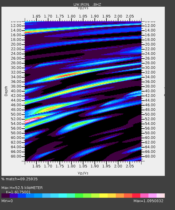
| Estimated Moho Depth: |
52.5 km |
| Estimated Crust Vp/Vs: |
1.62 |
| Assumed Crust Vp: |
6.279 km/s |
| Estimated Crust Vs: |
3.882 km/s |
| Estimated Crust Poisson's Ratio: |
0.19 |
|
| Radial Match: |
89.25935 % |
| Radial Bump: |
400 |
| Transverse Match: |
80.7152 % |
| Transverse Bump: |
400 |
| SOD ConfigId: |
626651 |
| Insert Time: |
2014-04-18 02:14:30.649 +0000 |
| GWidth: |
2.5 |
| Max Bumps: |
400 |
| Tol: |
0.001 |
|
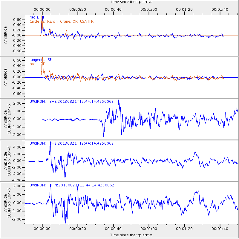
Signal To Noise
| Channel | StoN | STA | LTA |
| UW:IRON: :BHZ:20130821T12:44:14.425006Z | 23.691618 | 1.8506026E-6 | 7.811213E-8 |
| UW:IRON: :BHN:20130821T12:44:14.425006Z | 5.605497 | 6.9768055E-7 | 1.2446364E-7 |
| UW:IRON: :BHE:20130821T12:44:14.425006Z | 10.090444 | 6.5149686E-7 | 6.456573E-8 |
| Arrivals |
| Ps | 5.6 SECOND |
| PpPs | 20 SECOND |
| PsPs/PpSs | 26 SECOND |


