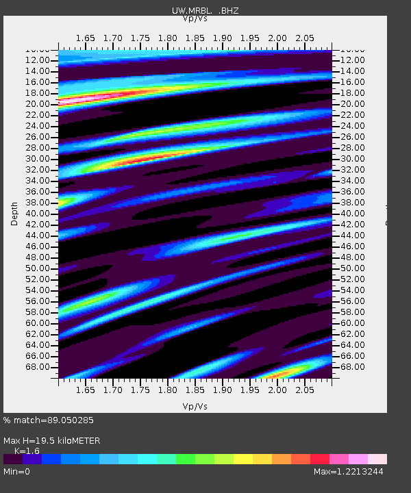
MRBL Marblemount, WA, USA - Earthquake Result Viewer
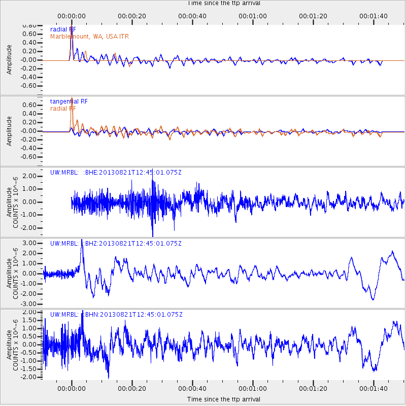
Earthquake location: Near Coast Of Guerrero, Mexico
Earthquake latitude/longitude: 16.9/-99.5
Earthquake time(UTC): 2013/08/21 (233) 12:38:29 GMT
Earthquake Depth: 21 km
Earthquake Magnitude: 6.2 MWW, 6.2 MWW, 6.2 MWB, 6.2 MWC
Earthquake Catalog/Contributor: NEIC PDE/NEIC COMCAT
Network: UW Pacific Northwest Regional Seismic Network
Station: MRBL Marblemount, WA, USA
Lat/Lon: 48.52 N/121.48 W
Elevation: 75 m
Distance: 36.3 deg
Az: 335.142 deg
Baz: 142.745 deg
Ray Param: 0.07672362
Estimated Moho Depth: 19.5 km
Estimated Crust Vp/Vs: 1.60
Assumed Crust Vp: 6.566 km/s
Estimated Crust Vs: 4.104 km/s
Estimated Crust Poisson's Ratio: 0.18
Radial Match: 89.050285 %
Radial Bump: 400
Transverse Match: 59.83959 %
Transverse Bump: 400
SOD ConfigId: 626651
Insert Time: 2014-04-18 02:14:53.574 +0000
GWidth: 2.5
Max Bumps: 400
Tol: 0.001

Signal To Noise

ChannelStoNSTALTA
UW:MRBL: :BHZ:20130821T12:45:01.075Z4.32798861.1578682E-62.675303E-7
UW:MRBL: :BHN:20130821T12:45:01.075Z1.44835397.246217E-75.0030707E-7
UW:MRBL: :BHE:20130821T12:45:01.075Z1.24880936.189303E-74.956163E-7
Arrivals
Ps1.9 SECOND
PpPs7.1 SECOND
PsPs/PpSs9.0 SECOND