You are here: Home > Network List > PF - Volcanologic Network of Piton de Fournaise-OVPF Stations List
> Station FRE Station Sismologique des Fonds de la Riviere de l'Est > Earthquake Result Viewer
FRE Station Sismologique des Fonds de la Riviere de l'Est - Earthquake Result Viewer
*The percent match for this event was below the threshold and hence no stack was calculated.
| Earthquake location: |
Philippine Islands Region |
| Earthquake latitude/longitude: |
10.0/126.8 |
| Earthquake time(UTC): |
2014/11/10 (314) 04:41:21 GMT |
| Earthquake Depth: |
64 km |
| Earthquake Magnitude: |
5.5 MB |
| Earthquake Catalog/Contributor: |
NEIC PDE/NEIC COMCAT |
|
| Network: |
PF Volcanologic Network of Piton de Fournaise-OVPF |
| Station: |
FRE Station Sismologique des Fonds de la Riviere de l'Est |
| Lat/Lon: |
21.20 S/55.70 E |
| Elevation: |
1775 m |
|
| Distance: |
76.4 deg |
| Az: |
245.293 deg |
| Baz: |
73.506 deg |
| Ray Param: |
$rayparam |
*The percent match for this event was below the threshold and hence was not used in the summary stack. |
|
| Radial Match: |
36.944805 % |
| Radial Bump: |
400 |
| Transverse Match: |
52.180286 % |
| Transverse Bump: |
400 |
| SOD ConfigId: |
3390531 |
| Insert Time: |
2019-04-14 22:06:42.470 +0000 |
| GWidth: |
2.5 |
| Max Bumps: |
400 |
| Tol: |
0.001 |
|
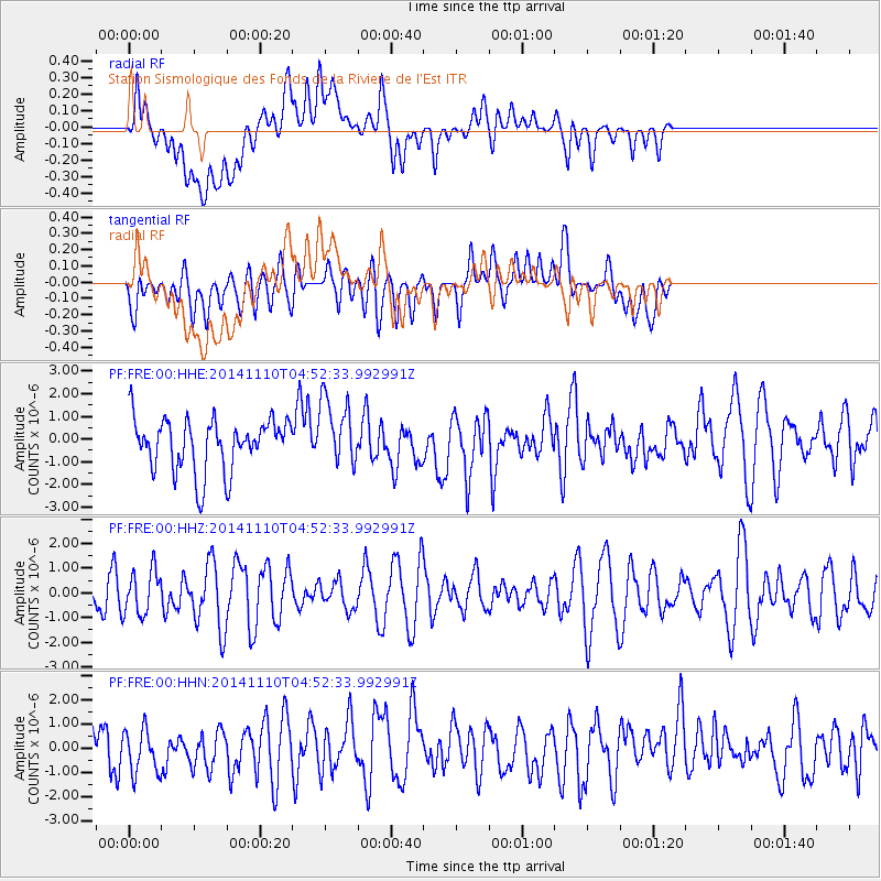
Signal To Noise
| Channel | StoN | STA | LTA |
| PF:FRE:00:HHZ:20141110T04:52:33.992991Z | 0.89365965 | 8.9725665E-7 | 1.0040251E-6 |
| PF:FRE:00:HHN:20141110T04:52:33.992991Z | 0.8092712 | 9.440249E-7 | 1.1665124E-6 |
| PF:FRE:00:HHE:20141110T04:52:33.992991Z | 1.2761883 | 1.4822449E-6 | 1.1614626E-6 |
| Arrivals |
| Ps | |
| PpPs | |
| PsPs/PpSs | |


